Gitarama geodata
Gitarama (Southern Province) is a seat of a second-order administrative division; located in Rwanda in Africa/Kigali (GMT+2) time zone. With population of 87,613 people, there are 2 cities with bigger population in this country. Compared to other cities in Rwanda, 53.8% of cities are located further ↑North; 61.5% of cities are located further ←West and 69.2% of cities have lower elevation than Gitarama. Note1
Administrative division(s):
- Level 1: Southern Province
- Level 2: Muhanga District
- Level 3: Nyamabuye
- Level 4: Gitarama


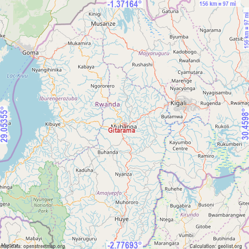
Gitarama GPS coordinates[2]
2° 4' 27.984" South, 29° 45' 24.012" East
| Map corner | latitude | longitude |
|---|---|---|
| Upper-left | -1.37164°, | 29.05355° |
| Center: | -2.07444°, | 29.75667° |
| Lower-right: | -2.77693°, | 30.4598° |
| Map W x H: | 156.3×156.3 km | = 97.1×97.1mi |
| max Lat: | -1.49984° ⇑53.8% North |
| Gitarama: | -2.07444° |
| min Lat: | ⇓46.2% South -2.59667° |
| min Long | Gitarama | max Long |
| 28.9075° | 29.75667° | 30.5427° |
| W 61.5%⇐ | ⇒38.5% E |
Elevation
Elevation of Gitarama is 1824 m = 5984 ft, and this is 87.1 m = 286 ft above average elevation for this country.
| Max E: |
2263 m = 7425 ft | 30.8% |
| Gitarama | 1824 m 5984 ft | |
| Avg. | 1736.9 m = 5698 ft | |
Min E: |
1461 m = 4793 ft | 69.2% |
See also: Gitarama elevation on elevation.city.
Geographical zone
Gitarama is located in South Torrid zone (between Equator and Tropic of Capricorn). Distance of Equator is 230.7 km =143.4 mi to North.| Distance of | km | miles | from Gitarama |
|---|---|---|---|
| Equator | 230.7 | 143.4 | to North |
| Tropic Capricorn | 2375.3 | 1475.9 | to South |
| Antarctic Circle | 7170.5 | 4455.5 | to South |
| South Pole | 9776.4 | 6074.8 | to South |


Nearby cities:
13 places around Gitarama: (largest is in red/bold)
• Butare
58.1 km =36.1 mi,  181°
181°
• Byumba
65.3 km =40.6 mi,  31°
31°
• Cyangugu
104.8 km =65.1 mi,  244°
244°
• Eglise Catholique, Centrale GIKO
16.3 km =10.1 mi,  19°
19°
• Gikongoro
47.8 km =29.7 mi,  205°
205°
• Gisenyi
69.3 km =43.1 mi,  306°
306°
• Kibungo
87.9 km =54.6 mi,  96°
96°
• Kibuye
45.5 km =28.3 mi,  271°
271°
• Kigali
36.3 km =22.6 mi,  67°
67°
• Musanze
65.3 km =40.6 mi,  348°
348°
• Nyanza
30.9 km =19.2 mi, 181°
• Nzega
50.2 km =31.2 mi, 206°
• Rwamagana
76.6 km =47.6 mi,  79°
79°
Sources, notices
• [Note1] Compared only with cities in Rwanda existing in our database
• [Src1] Map data: © OpenStreetMap contributors (CC-BY-SA)
• [Src2] Other city data from geonames.org with taken over terms of usage.
• [Src3] Geographical zone / Annual Mean Temperature by Robert A. Rohde @ Wikipedia
