Musanze geodata
Musanze (Northern Province) is a populated place; located in Rwanda in Africa/Kigali (GMT+2) time zone. With population of 86,685 people, there are 3 cities with bigger population in this country. Compared to other cities in Rwanda, 100% of cities are located further ↓South; 61.5% of cities are located further →East and 76.9% of cities have lower elevation than Musanze. Note1
Administrative division(s):
- Level 1: Northern Province
- Level 2: Musanze District
- Level 3: Cyuve
- Level 4: Rwebeya


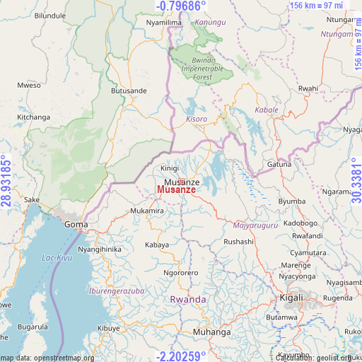
Musanze GPS coordinates[2]
1° 29' 59.424" South, 29° 38' 5.892" East
| Map corner | latitude | longitude |
|---|---|---|
| Upper-left | -0.79686°, | 28.93185° |
| Center: | -1.49984°, | 29.63497° |
| Lower-right: | -2.20259°, | 30.3381° |
| Map W x H: | 156.3×156.3 km | = 97.1×97.1mi |
| max Lat: | -1.49984° ⇑0% North |
| Musanze: | -1.49984° |
| min Lat: | ⇓100% South -2.59667° |
| min Long | Musanze | max Long |
| 28.9075° | 29.63497° | 30.5427° |
| W 38.5%⇐ | ⇒61.5% E |
Elevation
Elevation of Musanze is 1849 m = 6066 ft, and this is 112.1 m = 368 ft above average elevation for this country.
| Max E: |
2263 m = 7425 ft | 23.1% |
| Musanze | 1849 m 6066 ft | |
| Avg. | 1736.9 m = 5698 ft | |
Min E: |
1461 m = 4793 ft | 76.9% |
See also: Musanze elevation on elevation.city.
Geographical zone
Musanze is located in South Torrid zone (between Equator and Tropic of Capricorn). Distance of Equator is 166.8 km =103.6 mi to North.| Distance of | km | miles | from Musanze |
|---|---|---|---|
| Equator | 166.8 | 103.6 | to North |
| Tropic Capricorn | 2439.2 | 1515.6 | to South |
| Antarctic Circle | 7234.4 | 4495.2 | to South |
| South Pole | 9840.3 | 6114.5 | to South |


Nearby cities:
13 places around Musanze: (largest is in red/bold)
• Butare
122.5 km =76.1 mi,  174°
174°
• Byumba
48.8 km =30.3 mi,  100°
100°
• Cyangugu
136.1 km =84.6 mi,  216°
216°
• Eglise Catholique, Centrale GIKO
52.1 km =32.4 mi,  158°
158°
• Gikongoro
107.4 km =66.7 mi,  183°
183°
• Gisenyi
47.7 km =29.6 mi,  241°
241°
• Gitarama
65.3 km =40.6 mi, 168°
• Kibungo
124.7 km =77.5 mi,  126°
126°
• Kibuye
70 km =43.5 mi,  207°
207°
• Kigali
68.7 km =42.7 mi,  136°
136°
• Nyanza
95.6 km =59.4 mi, 172°
• Nzega
109.2 km =67.9 mi, 184°
• Rwamagana
101.9 km =63.3 mi,  119°
119°
Sources, notices
• [Note1] Compared only with cities in Rwanda existing in our database
• [Src1] Map data: © OpenStreetMap contributors (CC-BY-SA)
• [Src2] Other city data from geonames.org with taken over terms of usage.
• [Src3] Geographical zone / Annual Mean Temperature by Robert A. Rohde @ Wikipedia
