Kibuye geodata
Kibuye (Western Province) is a seat of a first-order administrative division; located in Rwanda in Africa/Kigali (GMT+2) time zone. With population of 48,024 people, there are 7 cities with bigger population in this country. Compared to other cities in Rwanda, 53.8% of cities are located further ↓South; 84.6% of cities are located further →East and 92.3% of cities have higher elevation than Kibuye. Note1
Administrative division(s):
- Level 1: Western Province
- Level 2: Karongi District
- Level 3: Bwishyura
- Level 4: Kibuye


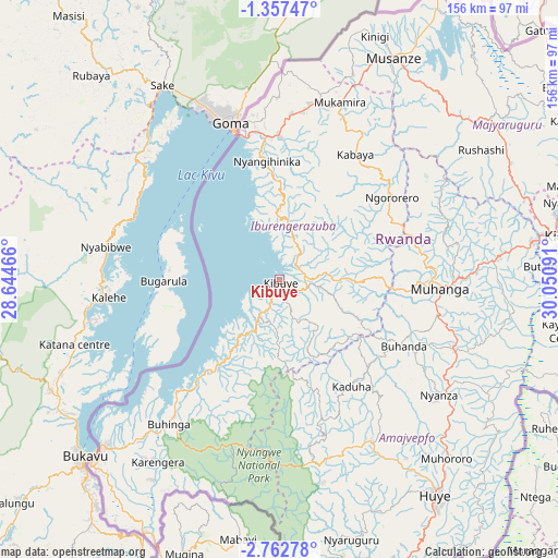
Kibuye GPS coordinates[2]
2° 3' 37.008" South, 29° 20' 52.008" East
| Map corner | latitude | longitude |
|---|---|---|
| Upper-left | -1.35747°, | 28.64466° |
| Center: | -2.06028°, | 29.34778° |
| Lower-right: | -2.76278°, | 30.05091° |
| Map W x H: | 156.3×156.3 km | = 97.1×97.1mi |
| max Lat: | -1.49984° ⇑46.2% North |
| Kibuye: | -2.06028° |
| min Lat: | ⇓53.8% South -2.59667° |
| min Long | Kibuye | max Long |
| 28.9075° | 29.34778° | 30.5427° |
| W 15.4%⇐ | ⇒84.6% E |
Elevation
Elevation of Kibuye is 1480 m = 4856 ft, and this is 256.9 m = 843 ft below average elevation for this country.
| Max E: |
2263 m = 7425 ft | 92.3% |
| Avg. | 1736.9 m = 5698 ft | |
| Kibuye | 1480 m = 4856 ft | |
Min E: |
1461 m = 4793 ft | 7.7% |
See also: Kibuye elevation on elevation.city.
Geographical zone
Kibuye is located in South Torrid zone (between Equator and Tropic of Capricorn). Distance of Equator is 229.1 km =142.4 mi to North.| Distance of | km | miles | from Kibuye |
|---|---|---|---|
| Equator | 229.1 | 142.4 | to North |
| Tropic Capricorn | 2376.8 | 1476.9 | to South |
| Antarctic Circle | 7172.1 | 4456.5 | to South |
| South Pole | 9778 | 6075.8 | to South |


Nearby cities:
13 places around Kibuye: (largest is in red/bold)
• Butare
73.8 km =45.9 mi,  143°
143°
• Byumba
96.4 km =59.9 mi,  56°
56°
• Cyangugu
68 km =42.3 mi,  226°
226°
• Eglise Catholique, Centrale GIKO
52.8 km =32.8 mi,  74°
74°
• Gikongoro
51.4 km =31.9 mi,  150°
150°
• Gisenyi
41 km =25.5 mi,  345°
345°
• Gitarama
45.5 km =28.3 mi,  91°
91°
• Kibungo
133.2 km =82.8 mi, 94°
• Kigali
80 km =49.7 mi,  81°
81°
• Musanze
70 km =43.5 mi,  27°
27°
• Nyanza
55.3 km =34.4 mi,  125°
125°
• Nzega
52 km =32.3 mi, 153°
• Rwamagana
121.4 km =75.4 mi, 84°
Sources, notices
• [Note1] Compared only with cities in Rwanda existing in our database
• [Src1] Map data: © OpenStreetMap contributors (CC-BY-SA)
• [Src2] Other city data from geonames.org with taken over terms of usage.
• [Src3] Geographical zone / Annual Mean Temperature by Robert A. Rohde @ Wikipedia
