Gisenyi geodata
Gisenyi (Western Province) is a seat of a second-order administrative division; located in Rwanda in Africa/Kigali (GMT+2) time zone. With population of 83,623 people, there are 4 cities with bigger population in this country. Compared to other cities in Rwanda, 84.6% of cities are located further ↓South; 92.3% of cities are located further →East and 100% of cities have higher elevation than Gisenyi. Note1


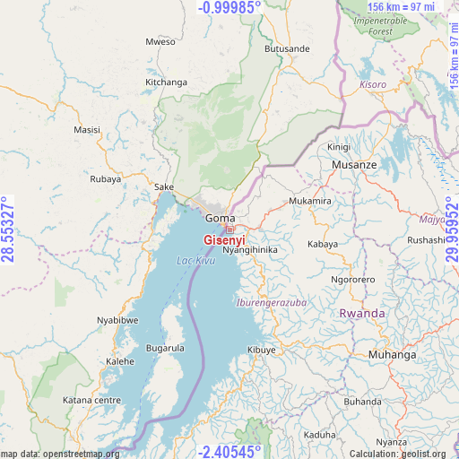
Gisenyi GPS coordinates[2]
1° 42' 10.008" South, 29° 15' 23.004" East
| Map corner | latitude | longitude |
|---|---|---|
| Upper-left | -0.99985°, | 28.55327° |
| Center: | -1.70278°, | 29.25639° |
| Lower-right: | -2.40545°, | 29.95952° |
| Map W x H: | 156.3×156.3 km | = 97.1×97.1mi |
| max Lat: | -1.49984° ⇑15.4% North |
| Gisenyi: | -1.70278° |
| min Lat: | ⇓84.6% South -2.59667° |
| min Long | Gisenyi | max Long |
| 28.9075° | 29.25639° | 30.5427° |
| W 7.7%⇐ | ⇒92.3% E |
Elevation
Elevation of Gisenyi is 1461 m = 4793 ft, and this is 275.9 m = 905 ft below average elevation for this country.
| Max E: |
2263 m = 7425 ft | 100% |
| Avg. | 1736.9 m = 5698 ft | |
| Gisenyi | 1461 m = 4793 ft | |
Min E: |
1461 m = 4793 ft | 0% |
See also: Gisenyi elevation on elevation.city.
Geographical zone
Gisenyi is located in South Torrid zone (between Equator and Tropic of Capricorn). Distance of Equator is 189.3 km =117.6 mi to North.| Distance of | km | miles | from Gisenyi |
|---|---|---|---|
| Equator | 189.3 | 117.6 | to North |
| Tropic Capricorn | 2416.6 | 1501.6 | to South |
| Antarctic Circle | 7211.8 | 4481.2 | to South |
| South Pole | 9817.7 | 6100.4 | to South |


Nearby cities:
13 places around Gisenyi: (largest is in red/bold)
• Butare
113 km =70.2 mi,  151°
151°
• Byumba
91.2 km =56.7 mi,  81°
81°
• Cyangugu
95.2 km =59.2 mi,  204°
204°
• Eglise Catholique, Centrale GIKO
66.4 km =41.3 mi,  113°
113°
• Gikongoro
91.7 km =57 mi,  157°
157°
• Gitarama
69.3 km =43.1 mi,  126°
126°
• Kibungo
151.7 km =94.3 mi, 109°
• Kibuye
41 km =25.5 mi,  165°
165°
• Kigali
93.3 km =58 mi, 107°
• Musanze
47.7 km =29.6 mi,  61°
61°
• Nyanza
90.7 km =56.4 mi,  142°
142°
• Nzega
92.5 km =57.5 mi, 158°
• Rwamagana
133.8 km =83.1 mi,  101°
101°
Sources, notices
• [Note1] Compared only with cities in Rwanda existing in our database
• [Src1] Map data: © OpenStreetMap contributors (CC-BY-SA)
• [Src2] Other city data from geonames.org with taken over terms of usage.
• [Src3] Geographical zone / Annual Mean Temperature by Robert A. Rohde @ Wikipedia
