Cyangugu geodata
Cyangugu (Western Province) is a populated place; located in Rwanda in Africa/Kigali (GMT+2) time zone. With population of 63,883 people, there are 6 cities with bigger population in this country. Compared to other cities in Rwanda, 92.3% of cities are located further ↑North; 100% of cities are located further →East and 69.2% of cities have higher elevation than Cyangugu. Note1
Administrative division(s):
- Level 1: Western Province
- Level 2: Rusizi District
- Level 3: Kamembe
- Level 4: Cyangugu


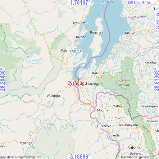
Cyangugu GPS coordinates[2]
2° 29' 4.56" South, 28° 54' 27" East
| Map corner | latitude | longitude |
|---|---|---|
| Upper-left | -1.78197°, | 28.20438° |
| Center: | -2.4846°, | 28.9075° |
| Lower-right: | -3.18686°, | 29.61063° |
| Map W x H: | 156.2×156.2 km | = 97.1×97.1mi |
| max Lat: | -1.49984° ⇑92.3% North |
| Cyangugu: | -2.4846° |
| min Lat: | ⇓7.7% South -2.59667° |
| min Long | Cyangugu | max Long |
| 28.9075° | 28.9075° | 30.5427° |
| W 0%⇐ | ⇒100% E |
Elevation
Elevation of Cyangugu is 1582 m = 5190 ft, and this is 154.9 m = 508 ft below average elevation for this country.
| Max E: |
2263 m = 7425 ft | 69.2% |
| Avg. | 1736.9 m = 5698 ft | |
| Cyangugu | 1582 m = 5190 ft | |
Min E: |
1461 m = 4793 ft | 30.8% |
See also: Cyangugu elevation on elevation.city.
Geographical zone
Cyangugu is located in South Torrid zone (between Equator and Tropic of Capricorn). Distance of Equator is 276.3 km =171.7 mi to North.| Distance of | km | miles | from Cyangugu |
|---|---|---|---|
| Equator | 276.3 | 171.7 | to North |
| Tropic Capricorn | 2329.7 | 1447.6 | to South |
| Antarctic Circle | 7124.9 | 4427.2 | to South |
| South Pole | 9730.8 | 6046.4 | to South |


Nearby cities:
13 places around Cyangugu: (largest is in red/bold)
• Butare
93.2 km =57.9 mi,  97°
97°
• Byumba
163.8 km =101.8 mi,  51°
51°
• Eglise Catholique, Centrale GIKO
117 km =72.7 mi,  58°
58°
• Gikongoro
74.1 km =46 mi,  88°
88°
• Gisenyi
95.2 km =59.2 mi,  24°
24°
• Gitarama
104.8 km =65.1 mi, 64°
• Kibungo
185.2 km =115.1 mi,  78°
78°
• Kibuye
68 km =42.3 mi, 46°
• Kigali
141.1 km =87.7 mi,  65°
65°
• Musanze
136.1 km =84.6 mi,  36°
36°
• Nyanza
94.8 km =58.9 mi, 81°
• Nzega
72.1 km =44.8 mi, 89°
• Rwamagana
179.8 km =111.7 mi, 70°
Sources, notices
• [Note1] Compared only with cities in Rwanda existing in our database
• [Src1] Map data: © OpenStreetMap contributors (CC-BY-SA)
• [Src2] Other city data from geonames.org with taken over terms of usage.
• [Src3] Geographical zone / Annual Mean Temperature by Robert A. Rohde @ Wikipedia
