Wad Rāwah geodata
Wad Rāwah (Al Jazīrah) is a populated place; located in Sudan in Africa/Khartoum (GMT+2) time zone. With population of 10,348 people, there are 60 cities with bigger population in this country. Compared to other cities in Sudan, 70.4% of cities are located further ↓South; 57.7% of cities are located further ←West and 67.6% of cities have higher elevation than Wad Rāwah. Note1


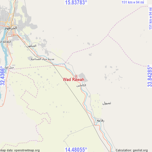
Wad Rāwah GPS coordinates[2]
15° 9' 37.008" North, 33° 8' 22.992" East
| Map corner | latitude | longitude |
|---|---|---|
| Upper-left | 15.83783°, | 32.4366° |
| Center: | 15.16028°, | 33.13972° |
| Lower-right: | 14.48055°, | 33.84285° |
| Map W x H: | 150.9×150.9 km | = 93.8×93.8mi |
| max Lat: | 21.06667° ⇑29.6% North |
| Wad Rāwah: | 15.16028° |
| min Lat: | ⇓70.4% South 10.55° |
| min Long | Wad Rāwah | max Long |
| 22.44725° | 33.13972° | 37.729° |
| W 57.7%⇐ | ⇒42.3% E |
Elevation
Elevation of Wad Rāwah is 394 m = 1293 ft, and this is 55.1 m = 181 ft below average elevation for this country.
| Max E: |
1159 m = 3802 ft | 67.6% |
| Avg. | 449.1 m = 1473 ft | |
| Wad Rāwah | 394 m = 1293 ft | |
Min E: |
4 m = 13 ft | 32.4% |
See also: Sudan elevation on elevation.city.
Geographical zone
Wad Rāwah is located in North Torrid zone (between Equator and Tropic of Cancer). Distance of this Northern Tropic circle is 920.3 km =571.8 mi to North.| Distance of | km | miles | from Wad Rāwah |
|---|---|---|---|
| North Pole | 8321.4 | 5170.7 | to North |
| Arctic Circle | 5715.5 | 3551.4 | to North |
| Tropic Cancer | 920.3 | 571.8 | to North |
| Equator | 1685.7 | 1047.4 | to South |


Nearby cities:
15 places around Wad Rāwah: (largest is in red/bold)
• Ad Douiem
156.7 km =97.4 mi,  214°
214°
• Al Hasaheisa
48.4 km =30.1 mi,  159°
159°
• Al Hilāliyya
26.5 km =16.5 mi, 157°
• Al Kawa
171.7 km =106.7 mi,  203°
203°
• Al Kiremit al ‘Arakiyyīn
92.8 km =57.7 mi,  193°
193°
• Al Manāqil
103 km =64 mi, 189°
• Al Masallamiyya
68.5 km =42.6 mi, 161°
• Al Qiţena
89.3 km =55.5 mi,  248°
248°
• Khartoum
78.3 km =48.7 mi,  303°
303°
• Kināna
125 km =77.7 mi,  178°
178°
• Omdurman
89.1 km =55.4 mi,  307°
307°
• Shendi
173.1 km =107.6 mi,  10°
10°
• Um Jar Al Gharbiyya
170.4 km =105.9 mi, 207°
• Wad Medani
93.8 km =58.3 mi,  154°
154°
• Wad az Zāki
126.9 km =78.9 mi,  232°
232°
Sources, notices
• [Note1] Compared only with cities in Sudan existing in our database
• [Src1] Map data: © OpenStreetMap contributors (CC-BY-SA)
• [Src2] Other city data from geonames.org with taken over terms of usage.
• [Src3] Geographical zone / Annual Mean Temperature by Robert A. Rohde @ Wikipedia
