Al Hilāliyya geodata
Al Hilāliyya (Al Jazīrah) is a populated place; located in Sudan in Africa/Khartoum (GMT+2) time zone. With population of 17,345 people, there are 44 cities with bigger population in this country. Compared to other cities in Sudan, 69% of cities are located further ↓South; 60.6% of cities are located further ←West and 66.2% of cities have higher elevation than Al Hilāliyya. Note1


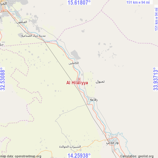
Al Hilāliyya GPS coordinates[2]
14° 56' 23.28" North, 33° 14' 2.4" East
| Map corner | latitude | longitude |
|---|---|---|
| Upper-left | 15.61807°, | 32.53088° |
| Center: | 14.9398°, | 33.234° |
| Lower-right: | 14.25938°, | 33.93713° |
| Map W x H: | 151.1×151.1 km | = 93.9×93.9mi |
| max Lat: | 21.06667° ⇑31% North |
| Al Hilāliyya: | 14.9398° |
| min Lat: | ⇓69% South 10.55° |
| min Long | Al Hilāliyya | max Long |
| 22.44725° | 33.234° | 37.729° |
| W 60.6%⇐ | ⇒39.4% E |
Elevation
Elevation of Al Hilāliyya is 398 m = 1306 ft, and this is 51.1 m = 168 ft below average elevation for this country.
| Max E: |
1159 m = 3802 ft | 66.2% |
| Avg. | 449.1 m = 1473 ft | |
| Al Hilāliyya | 398 m = 1306 ft | |
Min E: |
4 m = 13 ft | 33.8% |
See also: Sudan elevation on elevation.city.
Geographical zone
Al Hilāliyya is located in North Torrid zone (between Equator and Tropic of Cancer). Distance of this Northern Tropic circle is 944.8 km =587.1 mi to North.| Distance of | km | miles | from Al Hilāliyya |
|---|---|---|---|
| North Pole | 8345.9 | 5185.9 | to North |
| Arctic Circle | 5740 | 3566.7 | to North |
| Tropic Cancer | 944.8 | 587.1 | to North |
| Equator | 1661.2 | 1032.2 | to South |


Nearby cities:
15 places around Al Hilāliyya: (largest is in red/bold)
• Ad Douiem
144.1 km =89.5 mi,  223°
223°
• Al Hasaheisa
21.9 km =13.6 mi,  161°
161°
• Al Kawa
154.5 km =96 mi,  210°
210°
• Al Kiremit al ‘Arakiyyīn
72.9 km =45.3 mi, 205°
• Al Manāqil
81.5 km =50.6 mi,  198°
198°
• Al Masallamiyya
42.1 km =26.2 mi, 164°
• Al Qiţena
93.6 km =58.2 mi,  264°
264°
• Khartoum
101.5 km =63.1 mi,  312°
312°
• Kināna
100.7 km =62.6 mi,  183°
183°
• Omdurman
112.8 km =70.1 mi, 314°
• Sinnar
156.6 km =97.3 mi,  166°
166°
• Um Jar Al Gharbiyya
154.7 km =96.1 mi, 215°
• Wad Medani
67.3 km =41.8 mi,  152°
152°
• Wad Rāwah
26.5 km =16.5 mi,  337°
337°
• Wad az Zāki
122.6 km =76.2 mi,  244°
244°
Sources, notices
• [Note1] Compared only with cities in Sudan existing in our database
• [Src1] Map data: © OpenStreetMap contributors (CC-BY-SA)
• [Src2] Other city data from geonames.org with taken over terms of usage.
• [Src3] Geographical zone / Annual Mean Temperature by Robert A. Rohde @ Wikipedia
