Al Kawa geodata
Al Kawa (White Nile) is a populated place; located in Sudan in Africa/Khartoum (GMT+2) time zone. With population of 10,167 people, there are 62 cities with bigger population in this country. Compared to other cities in Sudan, 50.7% of cities are located further ↓South; 50.7% of cities are located further →East and 76.1% of cities have higher elevation than Al Kawa. Note1


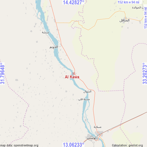
Al Kawa GPS coordinates[2]
13° 44' 46.68" North, 32° 29' 58.56" East
| Map corner | latitude | longitude |
|---|---|---|
| Upper-left | 14.42827°, | 31.79648° |
| Center: | 13.7463°, | 32.4996° |
| Lower-right: | 13.06233°, | 33.20273° |
| Map W x H: | 151.9×151.9 km | = 94.4×94.4mi |
| max Lat: | 21.06667° ⇑49.3% North |
| Al Kawa: | 13.7463° |
| min Lat: | ⇓50.7% South 10.55° |
| min Long | Al Kawa | max Long |
| 22.44725° | 32.4996° | 37.729° |
| W 49.3%⇐ | ⇒50.7% E |
Elevation
Elevation of Al Kawa is 385 m = 1263 ft, and this is 64.1 m = 210 ft below average elevation for this country.
| Max E: |
1159 m = 3802 ft | 76.1% |
| Avg. | 449.1 m = 1473 ft | |
| Al Kawa | 385 m = 1263 ft | |
Min E: |
4 m = 13 ft | 23.9% |
See also: Sudan elevation on elevation.city.
Geographical zone
Al Kawa is located in North Torrid zone (between Equator and Tropic of Cancer). Distance of this Northern Tropic circle is 1077.5 km =669.5 mi to North.| Distance of | km | miles | from Al Kawa |
|---|---|---|---|
| North Pole | 8478.6 | 5268.4 | to North |
| Arctic Circle | 5872.7 | 3649.1 | to North |
| Tropic Cancer | 1077.5 | 669.5 | to North |
| Equator | 1528.4 | 949.7 | to South |


Nearby cities:
15 places around Al Kawa: (largest is in red/bold)
• Ad Douiem
34.9 km =21.7 mi,  324°
324°
• Al Hasaheisa
141.2 km =87.7 mi,  37°
37°
• Al Kiremit al ‘Arakiyyīn
82.2 km =51.1 mi, 35°
• Al Manāqil
76.6 km =47.6 mi, 43°
• Al Masallamiyya
129 km =80.2 mi, 44°
• Al Qiţena
125.2 km =77.8 mi,  353°
353°
• Kināna
79.3 km =49.3 mi,  66°
66°
• Kosti
67.2 km =41.8 mi,  164°
164°
• Maiurno
131.4 km =81.6 mi,  106°
106°
• Rabak
68 km =42.3 mi, 157°
• Sinnar
117 km =72.7 mi,  99°
99°
• Tandaltī
106.2 km =66 mi,  220°
220°
• Um Jar Al Gharbiyya
11.6 km =7.2 mi,  301°
301°
• Wad Medani
132 km =82 mi,  56°
56°
• Wad az Zāki
85.6 km =53.2 mi,  338°
338°
Sources, notices
• [Note1] Compared only with cities in Sudan existing in our database
• [Src1] Map data: © OpenStreetMap contributors (CC-BY-SA)
• [Src2] Other city data from geonames.org with taken over terms of usage.
• [Src3] Geographical zone / Annual Mean Temperature by Robert A. Rohde @ Wikipedia
