Omdurman geodata
Omdurman (Khartoum) is a populated place; located in Sudan in Africa/Khartoum (GMT+2) time zone. With population of 1,200,000 people, there is 1 city with bigger population in this country. Compared to other cities in Sudan, 74.6% of cities are located further ↓South; 52.1% of cities are located further →East and 69% of cities have higher elevation than Omdurman. Note1


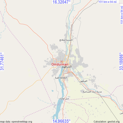
Omdurman GPS coordinates[2]
15° 38' 40.308" North, 32° 28' 39.828" East
| Map corner | latitude | longitude |
|---|---|---|
| Upper-left | 16.32047°, | 31.77461° |
| Center: | 15.64453°, | 32.47773° |
| Lower-right: | 14.96635°, | 33.18086° |
| Map W x H: | 150.6×150.6 km | = 93.6×93.6mi |
| max Lat: | 21.06667° ⇑25.4% North |
| Omdurman: | 15.64453° |
| min Lat: | ⇓74.6% South 10.55° |
| min Long | Omdurman | max Long |
| 22.44725° | 32.47773° | 37.729° |
| W 47.9%⇐ | ⇒52.1% E |
Elevation
Elevation of Omdurman is 391 m = 1283 ft, and this is 58.1 m = 191 ft below average elevation for this country.
| Max E: |
1159 m = 3802 ft | 69% |
| Avg. | 449.1 m = 1473 ft | |
| Omdurman | 391 m = 1283 ft | |
Min E: |
4 m = 13 ft | 31% |
See also: Omdurman elevation on elevation.city.
Geographical zone
Omdurman is located in North Torrid zone (between Equator and Tropic of Cancer). Distance of this Northern Tropic circle is 866.4 km =538.4 mi to North.| Distance of | km | miles | from Omdurman |
|---|---|---|---|
| North Pole | 8267.6 | 5137.2 | to North |
| Arctic Circle | 5661.7 | 3518 | to North |
| Tropic Cancer | 866.4 | 538.4 | to North |
| Equator | 1739.5 | 1080.9 | to South |


Nearby cities:
15 places around Omdurman: (largest is in red/bold)
• Ad Douiem
183.6 km =114.1 mi,  185°
185°
• Al Hasaheisa
132.6 km =82.4 mi,  138°
138°
• Al Hilāliyya
112.8 km =70.1 mi,  134°
134°
• Al Kiremit al ‘Arakiyyīn
152.6 km =94.8 mi,  160°
160°
• Al Manāqil
164.9 km =102.5 mi, 160°
• Al Masallamiyya
150.5 km =93.5 mi, 142°
• Al Qiţena
87.5 km =54.4 mi, 187°
• El Matama
151.1 km =93.9 mi,  38°
38°
• Khartoum
11.9 km =7.4 mi,  150°
150°
• Kināna
193.7 km =120.4 mi, 157°
• Shendi
154.9 km =96.3 mi, 41°
• Um Jar Al Gharbiyya
205.1 km =127.4 mi,  182°
182°
• Wad Medani
177.9 km =110.5 mi, 141°
• Wad Rāwah
89.1 km =55.4 mi, 127°
• Wad az Zāki
134.7 km =83.7 mi, 192°
Sources, notices
• [Note1] Compared only with cities in Sudan existing in our database
• [Src1] Map data: © OpenStreetMap contributors (CC-BY-SA)
• [Src2] Other city data from geonames.org with taken over terms of usage.
• [Src3] Geographical zone / Annual Mean Temperature by Robert A. Rohde @ Wikipedia
