Wad Medani geodata
Wad Medani (Al Jazīrah) is a seat of a first-order administrative division; located in Sudan in Africa/Khartoum (GMT+2) time zone. With population of 332,714 people, there are 8 cities with bigger population in this country. Compared to other cities in Sudan, 62% of cities are located further ↓South; 67.6% of cities are located further ←West and 57.7% of cities have higher elevation than Wad Medani. Note1


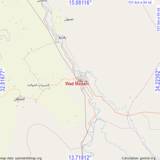
Wad Medani GPS coordinates[2]
14° 24' 4.248" North, 33° 31' 11.604" East
| Map corner | latitude | longitude |
|---|---|---|
| Upper-left | 15.08116°, | 32.81677° |
| Center: | 14.40118°, | 33.51989° |
| Lower-right: | 13.71912°, | 34.22302° |
| Map W x H: | 151.4×151.4 km | = 94.1×94.1mi |
| max Lat: | 21.06667° ⇑38% North |
| Wad Medani: | 14.40118° |
| min Lat: | ⇓62% South 10.55° |
| min Long | Wad Medani | max Long |
| 22.44725° | 33.51989° | 37.729° |
| W 67.6%⇐ | ⇒32.4% E |
Elevation
Elevation of Wad Medani is 410 m = 1345 ft, and this is 39.1 m = 128 ft below average elevation for this country.
| Max E: |
1159 m = 3802 ft | 57.7% |
| Avg. | 449.1 m = 1473 ft | |
| Wad Medani | 410 m = 1345 ft | |
Min E: |
4 m = 13 ft | 42.3% |
See also: Wad Medani elevation on elevation.city.
Geographical zone
Wad Medani is located in North Torrid zone (between Equator and Tropic of Cancer). Distance of this Northern Tropic circle is 1004.7 km =624.3 mi to North.| Distance of | km | miles | from Wad Medani |
|---|---|---|---|
| North Pole | 8405.8 | 5223.1 | to North |
| Arctic Circle | 5799.9 | 3603.9 | to North |
| Tropic Cancer | 1004.7 | 624.3 | to North |
| Equator | 1601.3 | 995 | to South |


Nearby cities:
15 places around Wad Medani: (largest is in red/bold)
• Ad Douiem
137.6 km =85.5 mi,  251°
251°
• Al Hasaheisa
45.8 km =28.5 mi,  328°
328°
• Al Hilāliyya
67.3 km =41.8 mi, 332°
• Al Kawa
132 km =82 mi,  236°
236°
• Al Kiremit al ‘Arakiyyīn
62.3 km =38.7 mi,  264°
264°
• Al Manāqil
59.7 km =37.1 mi, 253°
• Al Masallamiyya
27.6 km =17.1 mi,  314°
314°
• Al Qiţena
134.3 km =83.5 mi,  292°
292°
• As Sūkī
126.8 km =78.8 mi,  161°
161°
• Kināna
55.3 km =34.4 mi,  222°
222°
• Maiurno
110.6 km =68.7 mi,  171°
171°
• Sinnar
92.7 km =57.6 mi,  176°
176°
• Um Jar Al Gharbiyya
137.2 km =85.3 mi, 240°
• Wad Rāwah
93.8 km =58.3 mi, 334°
• Wad az Zāki
141.6 km =88 mi,  272°
272°
Sources, notices
• [Note1] Compared only with cities in Sudan existing in our database
• [Src1] Map data: © OpenStreetMap contributors (CC-BY-SA)
• [Src2] Other city data from geonames.org with taken over terms of usage.
• [Src3] Geographical zone / Annual Mean Temperature by Robert A. Rohde @ Wikipedia
