Khartoum geodata
Khartoum is a capital of a political entity; located in Sudan in Africa/Khartoum (GMT+2) time zone. With population of 1,974,647 people, there are 0 cities with bigger population in this country. Compared to other cities in Sudan, 73.2% of cities are located further ↓South; 50.7% of cities are located further ←West and 78.9% of cities have higher elevation than Khartoum. Note1


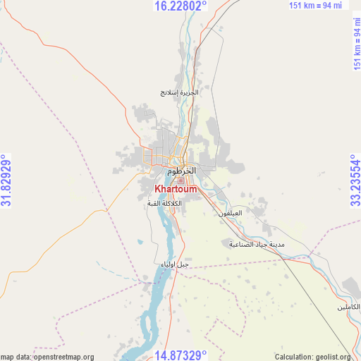
Khartoum GPS coordinates[2]
15° 33' 6.372" North, 32° 31' 56.676" East
| Map corner | latitude | longitude |
|---|---|---|
| Upper-left | 16.22802°, | 31.82929° |
| Center: | 15.55177°, | 32.53241° |
| Lower-right: | 14.87329°, | 33.23554° |
| Map W x H: | 150.6×150.6 km | = 93.6×93.6mi |
| max Lat: | 21.06667° ⇑26.8% North |
| Khartoum: | 15.55177° |
| min Lat: | ⇓73.2% South 10.55° |
| min Long | Khartoum | max Long |
| 22.44725° | 32.53241° | 37.729° |
| W 50.7%⇐ | ⇒49.3% E |
Elevation
Elevation of Khartoum is 381 m = 1250 ft, and this is 68.1 m = 223 ft below average elevation for this country.
| Max E: |
1159 m = 3802 ft | 78.9% |
| Avg. | 449.1 m = 1473 ft | |
| Khartoum | 381 m = 1250 ft | |
Min E: |
4 m = 13 ft | 21.1% |
See also: Khartoum elevation on elevation.city.
Geographical zone
Khartoum is located in North Torrid zone (between Equator and Tropic of Cancer). Distance of this Northern Tropic circle is 876.7 km =544.8 mi to North.| Distance of | km | miles | from Khartoum |
|---|---|---|---|
| North Pole | 8277.9 | 5143.6 | to North |
| Arctic Circle | 5672 | 3524.4 | to North |
| Tropic Cancer | 876.7 | 544.8 | to North |
| Equator | 1729.2 | 1074.5 | to South |


Nearby cities:
15 places around Khartoum: (largest is in red/bold)
• Ad Douiem
174 km =108.1 mi,  187°
187°
• Al Hasaheisa
121 km =75.2 mi,  137°
137°
• Al Hilāliyya
101.5 km =63.1 mi,  132°
132°
• Al Kiremit al ‘Arakiyyīn
141 km =87.6 mi,  161°
161°
• Al Manāqil
153.3 km =95.3 mi, 161°
• Al Masallamiyya
138.8 km =86.2 mi, 141°
• Al Qiţena
78.4 km =48.7 mi, 193°
• El Matama
155.9 km =96.9 mi,  34°
34°
• Kināna
182 km =113.1 mi, 157°
• Omdurman
11.9 km =7.4 mi,  330°
330°
• Shendi
159.2 km =98.9 mi,  37°
37°
• Um Jar Al Gharbiyya
195.1 km =121.2 mi,  183°
183°
• Wad Medani
166.2 km =103.3 mi, 140°
• Wad Rāwah
78.3 km =48.7 mi,  123°
123°
• Wad az Zāki
126.1 km =78.4 mi,  196°
196°
In other languages:
- In Spanish: Jartum
- In German: Khartum
- In Italian: Khartum
- In Russian: Хартум
- In Chinese: 喀土穆
Sources, notices
• [Note1] Compared only with cities in Sudan existing in our database
• [Src1] Map data: © OpenStreetMap contributors (CC-BY-SA)
• [Src2] Other city data from geonames.org with taken over terms of usage.
• [Src3] Geographical zone / Annual Mean Temperature by Robert A. Rohde @ Wikipedia
