As Sūkī geodata
As Sūkī (Sinnār) is a populated place; located in Sudan in Africa/Khartoum (GMT+2) time zone. With population of 33,524 people, there are 26 cities with bigger population in this country. Compared to other cities in Sudan, 62% of cities are located further ↑North; 71.8% of cities are located further ←West and 50.7% of cities have lower elevation than As Sūkī. Note1


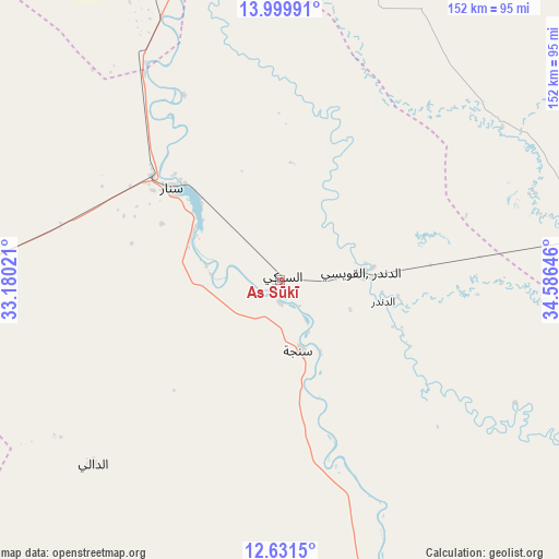
As Sūkī GPS coordinates[2]
13° 19' 0.012" North, 33° 52' 59.988" East
| Map corner | latitude | longitude |
|---|---|---|
| Upper-left | 13.99991°, | 33.18021° |
| Center: | 13.31667°, | 33.88333° |
| Lower-right: | 12.6315°, | 34.58646° |
| Map W x H: | 152.2×152.2 km | = 94.6×94.6mi |
| max Lat: | 21.06667° ⇑62% North |
| As Sūkī: | 13.31667° |
| min Lat: | ⇓38% South 10.55° |
| min Long | As Sūkī | max Long |
| 22.44725° | 33.88333° | 37.729° |
| W 71.8%⇐ | ⇒28.2% E |
Elevation
Elevation of As Sūkī is 428 m = 1404 ft, and this is 21.1 m = 69 ft below average elevation for this country.
| Max E: |
1159 m = 3802 ft | 49.3% |
| Avg. | 449.1 m = 1473 ft | |
| As Sūkī | 428 m = 1404 ft | |
Min E: |
4 m = 13 ft | 50.7% |
See also: Sudan elevation on elevation.city.
Geographical zone
As Sūkī is located in North Torrid zone (between Equator and Tropic of Cancer). Distance of this Northern Tropic circle is 1125.2 km =699.2 mi to North.| Distance of | km | miles | from As Sūkī |
|---|---|---|---|
| North Pole | 8526.4 | 5298.1 | to North |
| Arctic Circle | 5920.5 | 3678.8 | to North |
| Tropic Cancer | 1125.2 | 699.2 | to North |
| Equator | 1480.7 | 920.1 | to South |


Nearby cities:
15 places around As Sūkī: (largest is in red/bold)
• Ad Dindar
33.3 km =20.7 mi,  112°
112°
• Al Kawa
157 km =97.6 mi,  287°
287°
• Al Kiremit al ‘Arakiyyīn
153.1 km =95.1 mi,  318°
318°
• Al Manāqil
141.4 km =87.9 mi, 316°
• Al Masallamiyya
151.8 km =94.3 mi,  337°
337°
• Al Ḩawātah
81.9 km =50.9 mi,  82°
82°
• Jalqani
103.1 km =64.1 mi,  159°
159°
• Kināna
111 km =69 mi, 316°
• Kosti
133.1 km =82.7 mi,  262°
262°
• Maiurno
25.9 km =16.1 mi,  295°
295°
• Rabak
124.7 km =77.5 mi, 263°
• Singa
19.4 km =12.1 mi, 164°
• Sinnar
44.2 km =27.5 mi,  309°
309°
• Um Jar Al Gharbiyya
168.3 km =104.6 mi, 288°
• Wad Medani
126.8 km =78.8 mi, 341°
Sources, notices
• [Note1] Compared only with cities in Sudan existing in our database
• [Src1] Map data: © OpenStreetMap contributors (CC-BY-SA)
• [Src2] Other city data from geonames.org with taken over terms of usage.
• [Src3] Geographical zone / Annual Mean Temperature by Robert A. Rohde @ Wikipedia
