Maiurno geodata
Maiurno (Sinnār) is a populated place; located in Sudan in Africa/Khartoum (GMT+2) time zone. With population of 28,727 people, there are 29 cities with bigger population in this country. Compared to other cities in Sudan, 60.6% of cities are located further ↑North; 70.4% of cities are located further ←West and 52.1% of cities have higher elevation than Maiurno. Note1


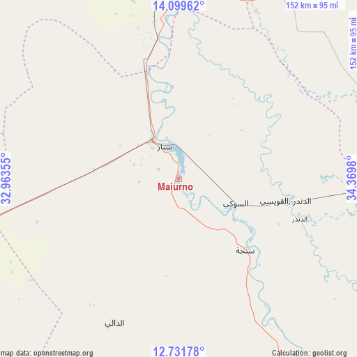
Maiurno GPS coordinates[2]
13° 25' 0.012" North, 33° 40' 0.012" East
| Map corner | latitude | longitude |
|---|---|---|
| Upper-left | 14.09962°, | 32.96355° |
| Center: | 13.41667°, | 33.66667° |
| Lower-right: | 12.73178°, | 34.3698° |
| Map W x H: | 152.1×152.1 km | = 94.5×94.5mi |
| max Lat: | 21.06667° ⇑60.6% North |
| Maiurno: | 13.41667° |
| min Lat: | ⇓39.4% South 10.55° |
| min Long | Maiurno | max Long |
| 22.44725° | 33.66667° | 37.729° |
| W 70.4%⇐ | ⇒29.6% E |
Elevation
Elevation of Maiurno is 423 m = 1388 ft, and this is 26.1 m = 86 ft below average elevation for this country.
| Max E: |
1159 m = 3802 ft | 52.1% |
| Avg. | 449.1 m = 1473 ft | |
| Maiurno | 423 m = 1388 ft | |
Min E: |
4 m = 13 ft | 47.9% |
See also: Sudan elevation on elevation.city.
Geographical zone
Maiurno is located in North Torrid zone (between Equator and Tropic of Cancer). Distance of this Northern Tropic circle is 1114.1 km =692.3 mi to North.| Distance of | km | miles | from Maiurno |
|---|---|---|---|
| North Pole | 8515.3 | 5291.2 | to North |
| Arctic Circle | 5909.4 | 3671.9 | to North |
| Tropic Cancer | 1114.1 | 692.3 | to North |
| Equator | 1491.8 | 927 | to South |


Nearby cities:
15 places around Maiurno: (largest is in red/bold)
• Ad Dindar
59.2 km =36.8 mi,  114°
114°
• Al Kawa
131.4 km =81.6 mi,  286°
286°
• Al Kiremit al ‘Arakiyyīn
129.6 km =80.5 mi,  322°
322°
• Al Manāqil
117.7 km =73.1 mi, 321°
• Al Masallamiyya
133.6 km =83 mi,  344°
344°
• Al Ḩawātah
104.5 km =64.9 mi,  90°
90°
• As Sūkī
25.9 km =16.1 mi,  115°
115°
• Jalqani
123.1 km =76.5 mi,  150°
150°
• Kināna
87.2 km =54.2 mi, 322°
• Kosti
112.2 km =69.7 mi,  255°
255°
• Rabak
103.6 km =64.4 mi, 255°
• Singa
41.3 km =25.7 mi,  136°
136°
• Sinnar
20.1 km =12.5 mi,  327°
327°
• Um Jar Al Gharbiyya
142.6 km =88.6 mi, 287°
• Wad Medani
110.6 km =68.7 mi,  351°
351°
Sources, notices
• [Note1] Compared only with cities in Sudan existing in our database
• [Src1] Map data: © OpenStreetMap contributors (CC-BY-SA)
• [Src2] Other city data from geonames.org with taken over terms of usage.
• [Src3] Geographical zone / Annual Mean Temperature by Robert A. Rohde @ Wikipedia
