Jalqani geodata
Jalqani (Sinnār) is a populated place; located in Sudan in Africa/Khartoum (GMT+2) time zone. With population of 9,472 people, there are 65 cities with bigger population in this country. Compared to other cities in Sudan, 77.5% of cities are located further ↑North; 81.7% of cities are located further ←West and 60.6% of cities have lower elevation than Jalqani. Note1


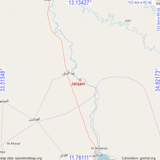
Jalqani GPS coordinates[2]
12° 26' 54.96" North, 34° 13' 6.96" East
| Map corner | latitude | longitude |
|---|---|---|
| Upper-left | 13.13427°, | 33.51548° |
| Center: | 12.4486°, | 34.2186° |
| Lower-right: | 11.76111°, | 34.92173° |
| Map W x H: | 152.7×152.7 km | = 94.9×94.9mi |
| max Lat: | 21.06667° ⇑77.5% North |
| Jalqani: | 12.4486° |
| min Lat: | ⇓22.5% South 10.55° |
| min Long | Jalqani | max Long |
| 22.44725° | 34.2186° | 37.729° |
| W 81.7%⇐ | ⇒18.3% E |
Elevation
Elevation of Jalqani is 454 m = 1490 ft, and this is 4.9 m = 16 ft above average elevation for this country.
| Max E: |
1159 m = 3802 ft | 39.4% |
| Jalqani | 454 m 1490 ft | |
| Avg. | 449.1 m = 1473 ft | |
Min E: |
4 m = 13 ft | 60.6% |
See also: Sudan elevation on elevation.city.
Geographical zone
Jalqani is located in North Torrid zone (between Equator and Tropic of Cancer). Distance of this Northern Tropic circle is 1221.8 km =759.2 mi to North.| Distance of | km | miles | from Jalqani |
|---|---|---|---|
| North Pole | 8622.9 | 5358 | to North |
| Arctic Circle | 6017 | 3738.8 | to North |
| Tropic Cancer | 1221.8 | 759.2 | to North |
| Equator | 1384.2 | 860.1 | to South |


Nearby cities:
15 places around Jalqani: (largest is in red/bold)
• Ad Dindar
83.7 km =52 mi,  356°
356°
• Ad-Damazin
74.9 km =46.5 mi,  168°
168°
• Al Qadarif
216.8 km =134.7 mi,  35°
35°
• Al Ḩawātah
116.6 km =72.5 mi,  22°
22°
• Ar Ruseris
67.3 km =41.8 mi,  164°
164°
• As Sūkī
103.1 km =64.1 mi,  339°
339°
• Doka
205.5 km =127.7 mi,  54°
54°
• Kināna
209.8 km =130.4 mi,  327°
327°
• Kosti
186.4 km =115.8 mi,  295°
295°
• Kurmuk
211.2 km =131.2 mi,  178°
178°
• Maiurno
123.1 km =76.5 mi, 330°
• Marabba
221.3 km =137.5 mi,  267°
267°
• Rabak
179.8 km =111.7 mi, 296°
• Singa
83.8 km =52.1 mi, 338°
• Sinnar
143.2 km =89 mi, 330°
Sources, notices
• [Note1] Compared only with cities in Sudan existing in our database
• [Src1] Map data: © OpenStreetMap contributors (CC-BY-SA)
• [Src2] Other city data from geonames.org with taken over terms of usage.
• [Src3] Geographical zone / Annual Mean Temperature by Robert A. Rohde @ Wikipedia
