Al Ḩawātah geodata
Al Ḩawātah (Al Qaḑārif) is a populated place; located in Sudan in Africa/Khartoum (GMT+2) time zone. With population of 24,513 people, there are 35 cities with bigger population in this country. Compared to other cities in Sudan, 60.6% of cities are located further ↑North; 87.3% of cities are located further ←West and 59.2% of cities have lower elevation than Al Ḩawātah. Note1


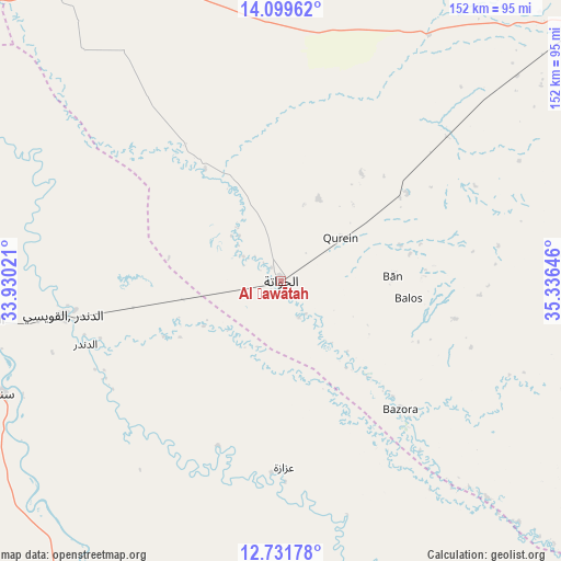
Al Ḩawātah GPS coordinates[2]
13° 25' 0.012" North, 34° 37' 59.988" East
| Map corner | latitude | longitude |
|---|---|---|
| Upper-left | 14.09962°, | 33.93021° |
| Center: | 13.41667°, | 34.63333° |
| Lower-right: | 12.73178°, | 35.33646° |
| Map W x H: | 152.1×152.1 km | = 94.5×94.5mi |
| max Lat: | 21.06667° ⇑60.6% North |
| Al Ḩawātah: | 13.41667° |
| min Lat: | ⇓39.4% South 10.55° |
| min Long | Al Ḩawātah | max Long |
| 22.44725° | 34.63333° | 37.729° |
| W 87.3%⇐ | ⇒12.7% E |
Elevation
Elevation of Al Ḩawātah is 445 m = 1460 ft, and this is 4.1 m = 13 ft below average elevation for this country.
| Max E: |
1159 m = 3802 ft | 40.8% |
| Avg. | 449.1 m = 1473 ft | |
| Al Ḩawātah | 445 m = 1460 ft | |
Min E: |
4 m = 13 ft | 59.2% |
See also: Sudan elevation on elevation.city.
Geographical zone
Al Ḩawātah is located in North Torrid zone (between Equator and Tropic of Cancer). Distance of this Northern Tropic circle is 1114.1 km =692.3 mi to North.| Distance of | km | miles | from Al Ḩawātah |
|---|---|---|---|
| North Pole | 8515.3 | 5291.2 | to North |
| Arctic Circle | 5909.4 | 3671.9 | to North |
| Tropic Cancer | 1114.1 | 692.3 | to North |
| Equator | 1491.8 | 927 | to South |


Nearby cities:
15 places around Al Ḩawātah: (largest is in red/bold)
• Ad Dindar
55.9 km =34.7 mi,  244°
244°
• Ad-Damazin
183.4 km =114 mi,  189°
189°
• Al Manāqil
200 km =124.3 mi,  297°
297°
• Al Masallamiyya
190.1 km =118.1 mi,  312°
312°
• Al Qadarif
106.3 km =66.1 mi,  49°
49°
• Ar Ruseris
174.5 km =108.4 mi, 188°
• As Sūkī
81.9 km =50.9 mi,  262°
262°
• Doka
123.1 km =76.5 mi,  84°
84°
• Jalqani
116.6 km =72.5 mi,  202°
202°
• Kināna
172.3 km =107.1 mi,  293°
293°
• Maiurno
104.5 km =64.9 mi,  270°
270°
• Rabak
206.5 km =128.3 mi, 262°
• Singa
81.6 km =50.7 mi,  248°
248°
• Sinnar
116.5 km =72.4 mi,  278°
278°
• Wad Medani
162.6 km =101 mi, 312°
Sources, notices
• [Note1] Compared only with cities in Sudan existing in our database
• [Src1] Map data: © OpenStreetMap contributors (CC-BY-SA)
• [Src2] Other city data from geonames.org with taken over terms of usage.
• [Src3] Geographical zone / Annual Mean Temperature by Robert A. Rohde @ Wikipedia
