Doka geodata
Doka (Al Qaḑārif) is a populated place; located in Sudan in Africa/Khartoum (GMT+2) time zone. With population of 19,821 people, there are 40 cities with bigger population in this country. Compared to other cities in Sudan, 56.3% of cities are located further ↑North; 90.1% of cities are located further ←West and 90.1% of cities have lower elevation than Doka. Note1


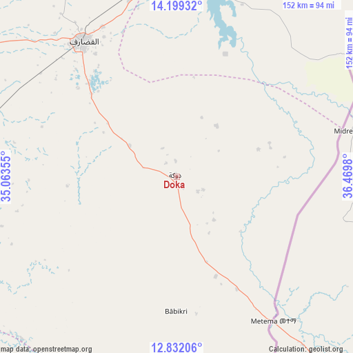
Doka GPS coordinates[2]
13° 31' 0.012" North, 35° 46' 0.012" East
| Map corner | latitude | longitude |
|---|---|---|
| Upper-left | 14.19932°, | 35.06355° |
| Center: | 13.51667°, | 35.76667° |
| Lower-right: | 12.83206°, | 36.4698° |
| Map W x H: | 152×152 km | = 94.4×94.4mi |
| max Lat: | 21.06667° ⇑56.3% North |
| Doka: | 13.51667° |
| min Lat: | ⇓43.7% South 10.55° |
| min Long | Doka | max Long |
| 22.44725° | 35.76667° | 37.729° |
| W 90.1%⇐ | ⇒9.9% E |
Elevation
Elevation of Doka is 643 m = 2110 ft, and this is 193.9 m = 636 ft above average elevation for this country.
| Max E: |
1159 m = 3802 ft | 9.9% |
| Doka | 643 m 2110 ft | |
| Avg. | 449.1 m = 1473 ft | |
Min E: |
4 m = 13 ft | 90.1% |
See also: Sudan elevation on elevation.city.
Geographical zone
Doka is located in North Torrid zone (between Equator and Tropic of Cancer). Distance of this Northern Tropic circle is 1103 km =685.4 mi to North.| Distance of | km | miles | from Doka |
|---|---|---|---|
| North Pole | 8504.1 | 5284.2 | to North |
| Arctic Circle | 5898.3 | 3665 | to North |
| Tropic Cancer | 1103 | 685.4 | to North |
| Equator | 1502.9 | 933.9 | to South |


Nearby cities:
15 places around Doka: (largest is in red/bold)
• Ad Dindar
176.6 km =109.7 mi,  258°
258°
• Ad-Damazin
245.4 km =152.5 mi,  218°
218°
• Al Masallamiyya
287.2 km =178.5 mi,  294°
294°
• Al Qadarif
70.9 km =44.1 mi,  324°
324°
• Al Ḩawātah
123.1 km =76.5 mi, 264°
• Ar Ruseris
236.8 km =147.1 mi, 219°
• Aroma
258.8 km =160.8 mi,  8°
8°
• As Sūkī
204.9 km =127.3 mi, 263°
• Jalqani
205.5 km =127.7 mi,  234°
234°
• Kassala
225.6 km =140.2 mi,  17°
17°
• Kināna
286.2 km =177.8 mi,  281°
281°
• Maiurno
227.3 km =141.2 mi,  267°
267°
• Singa
202.8 km =126 mi, 258°
• Sinnar
237.8 km =147.8 mi, 271°
• Wad Medani
261.6 km =162.6 mi, 292°
Sources, notices
• [Note1] Compared only with cities in Sudan existing in our database
• [Src1] Map data: © OpenStreetMap contributors (CC-BY-SA)
• [Src2] Other city data from geonames.org with taken over terms of usage.
• [Src3] Geographical zone / Annual Mean Temperature by Robert A. Rohde @ Wikipedia
