El Fasher geodata
El Fasher (Northern Darfur) is a seat of a first-order administrative division; located in Sudan in Africa/Khartoum (GMT+2) time zone. With population of 252,609 people, there are 10 cities with bigger population in this country. Compared to other cities in Sudan, 52.1% of cities are located further ↑North; 93% of cities are located further →East and 95.8% of cities have lower elevation than El Fasher. Note1


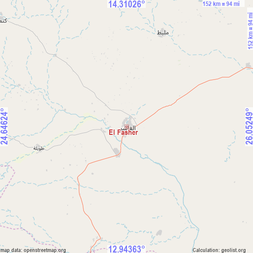
El Fasher GPS coordinates[2]
13° 37' 40.548" North, 25° 20' 57.696" East
| Map corner | latitude | longitude |
|---|---|---|
| Upper-left | 14.31026°, | 24.64624° |
| Center: | 13.62793°, | 25.34936° |
| Lower-right: | 12.94363°, | 26.05249° |
| Map W x H: | 152×152 km | = 94.4×94.4mi |
| max Lat: | 21.06667° ⇑52.1% North |
| El Fasher: | 13.62793° |
| min Lat: | ⇓47.9% South 10.55° |
| min Long | El Fasher | max Long |
| 22.44725° | 25.34936° | 37.729° |
| W 7%⇐ | ⇒93% E |
Elevation
Elevation of El Fasher is 748 m = 2454 ft, and this is 298.9 m = 981 ft above average elevation for this country.
| Max E: |
1159 m = 3802 ft | 4.2% |
| El Fasher | 748 m 2454 ft | |
| Avg. | 449.1 m = 1473 ft | |
Min E: |
4 m = 13 ft | 95.8% |
See also: El Fasher elevation on elevation.city.
Geographical zone
El Fasher is located in North Torrid zone (between Equator and Tropic of Cancer). Distance of this Northern Tropic circle is 1090.6 km =677.7 mi to North.| Distance of | km | miles | from El Fasher |
|---|---|---|---|
| North Pole | 8491.8 | 5276.6 | to North |
| Arctic Circle | 5885.9 | 3657.3 | to North |
| Tropic Cancer | 1090.6 | 677.7 | to North |
| Equator | 1515.3 | 941.6 | to South |


Nearby cities:
11 places around El Fasher: (largest is in red/bold)
• Al Fūlah
388.4 km =241.3 mi,  122°
122°
• Al Mijlad
387.7 km =240.9 mi,  138°
138°
• An Nuhūd
349.5 km =217.2 mi,  107°
107°
• El Daein
255.2 km =158.6 mi,  160°
160°
• El Fula
388.7 km =241.5 mi, 123°
• Geneina
314.3 km =195.3 mi,  266°
266°
• Gereida
262.6 km =163.2 mi,  184°
184°
• Kutum
97.3 km =60.5 mi,  310°
310°
• Nyala
182.8 km =113.6 mi,  196°
196°
• Umm Kaddadah
144.6 km =89.9 mi,  91°
91°
• Zalingei
218.5 km =135.8 mi,  248°
248°
Sources, notices
• [Note1] Compared only with cities in Sudan existing in our database
• [Src1] Map data: © OpenStreetMap contributors (CC-BY-SA)
• [Src2] Other city data from geonames.org with taken over terms of usage.
• [Src3] Geographical zone / Annual Mean Temperature by Robert A. Rohde @ Wikipedia
