Gereida geodata
Gereida (Southern Darfur) is a populated place; located in Sudan in Africa/Khartoum (GMT+2) time zone. With population of 120,000 people, there are 17 cities with bigger population in this country. Compared to other cities in Sudan, 94.4% of cities are located further ↑North; 94.4% of cities are located further →East and 67.6% of cities have lower elevation than Gereida. Note1


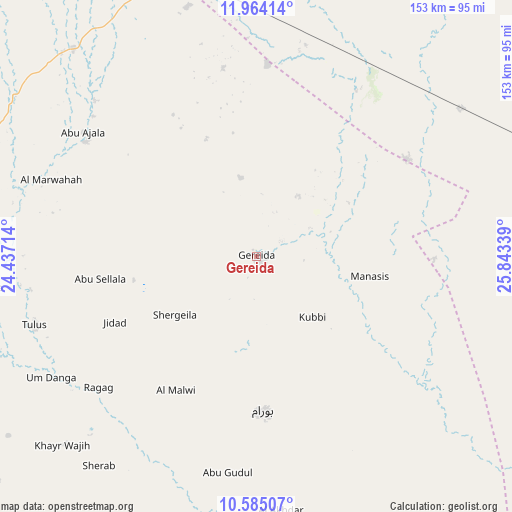
Gereida GPS coordinates[2]
11° 16' 31.548" North, 25° 8' 24.936" East
| Map corner | latitude | longitude |
|---|---|---|
| Upper-left | 11.96414°, | 24.43714° |
| Center: | 11.27543°, | 25.14026° |
| Lower-right: | 10.58507°, | 25.84339° |
| Map W x H: | 153.3×153.3 km | = 95.3×95.3mi |
| max Lat: | 21.06667° ⇑94.4% North |
| Gereida: | 11.27543° |
| min Lat: | ⇓5.6% South 10.55° |
| min Long | Gereida | max Long |
| 22.44725° | 25.14026° | 37.729° |
| W 5.6%⇐ | ⇒94.4% E |
Elevation
Elevation of Gereida is 483 m = 1585 ft, and this is 33.9 m = 111 ft above average elevation for this country.
| Max E: |
1159 m = 3802 ft | 32.4% |
| Gereida | 483 m 1585 ft | |
| Avg. | 449.1 m = 1473 ft | |
Min E: |
4 m = 13 ft | 67.6% |
See also: Gereida elevation on elevation.city.
Geographical zone
Gereida is located in North Torrid zone (between Equator and Tropic of Cancer). Distance of Equator is 1253.7 km =779 mi to South.| Distance of | km | miles | from Gereida |
|---|---|---|---|
| North Pole | 8753.4 | 5439.1 | to North |
| Arctic Circle | 6147.5 | 3819.9 | to North |
| Tropic Cancer | 1352.2 | 840.2 | to North |
| Equator | 1253.7 | 779 | to South |


Nearby cities:
12 places around Gereida: (largest is in red/bold)
• Al Fūlah
354.2 km =220.1 mi,  81°
81°
• Al Lagowa
435.5 km =270.6 mi,  88°
88°
• Al Mijlad
284.2 km =176.6 mi,  95°
95°
• An Nuhūd
391.6 km =243.3 mi,  66°
66°
• El Daein
109.4 km =68 mi, 79°
• El Fasher
262.6 km =163.2 mi,  4°
4°
• El Fula
352.7 km =219.2 mi, 82°
• Geneina
379.7 km =235.9 mi,  309°
309°
• Kutum
329.2 km =204.6 mi,  351°
351°
• Nyala
90.5 km =56.2 mi,  341°
341°
• Umm Kaddadah
308.4 km =191.6 mi,  33°
33°
• Zalingei
256.8 km =159.6 mi,  315°
315°
Sources, notices
• [Note1] Compared only with cities in Sudan existing in our database
• [Src1] Map data: © OpenStreetMap contributors (CC-BY-SA)
• [Src2] Other city data from geonames.org with taken over terms of usage.
• [Src3] Geographical zone / Annual Mean Temperature by Robert A. Rohde @ Wikipedia
