El Fula geodata
El Fula (West Kordofan State) is a seat of a first-order administrative division; located in Sudan in Africa/Khartoum (GMT+2) time zone. In our database, there are 71 cities with bigger population. Compared to other cities in Sudan, 88.7% of cities are located further ↑North; 87.3% of cities are located further →East and 76.1% of cities have lower elevation than El Fula. Note1


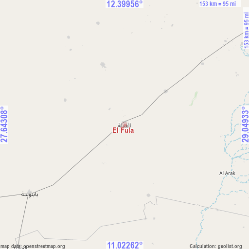
El Fula GPS coordinates[2]
11° 42' 43.02" North, 28° 20' 46.32" East
| Map corner | latitude | longitude |
|---|---|---|
| Upper-left | 12.39956°, | 27.64308° |
| Center: | 11.71195°, | 28.3462° |
| Lower-right: | 11.02262°, | 29.04933° |
| Map W x H: | 153.1×153.1 km | = 95.1×95.1mi |
| max Lat: | 21.06667° ⇑88.7% North |
| El Fula: | 11.71195° |
| min Lat: | ⇓11.3% South 10.55° |
| min Long | El Fula | max Long |
| 22.44725° | 28.3462° | 37.729° |
| W 12.7%⇐ | ⇒87.3% E |
Elevation
Elevation of El Fula is 517 m = 1696 ft, and this is 67.9 m = 223 ft above average elevation for this country.
| Max E: |
1159 m = 3802 ft | 23.9% |
| El Fula | 517 m 1696 ft | |
| Avg. | 449.1 m = 1473 ft | |
Min E: |
4 m = 13 ft | 76.1% |
See also: Sudan elevation on elevation.city.
Geographical zone
El Fula is located in North Torrid zone (between Equator and Tropic of Cancer). Distance of Equator is 1302.2 km =809.1 mi to South.| Distance of | km | miles | from El Fula |
|---|---|---|---|
| North Pole | 8704.8 | 5408.9 | to North |
| Arctic Circle | 6098.9 | 3789.7 | to North |
| Tropic Cancer | 1303.7 | 810.1 | to North |
| Equator | 1302.2 | 809.1 | to South |


Nearby cities:
15 places around El Fula: (largest is in red/bold)
• Abu Jibeha
315.2 km =195.9 mi,  95°
95°
• Abū Zabad
121.2 km =75.3 mi,  54°
54°
• Al Fūlah
2.7 km =1.7 mi,  28°
28°
• Al Lagowa
92.5 km =57.5 mi,  112°
112°
• Al Mijlad
100.8 km =62.6 mi,  221°
221°
• An Nuhūd
110.3 km =68.5 mi,  4°
4°
• Ar Rahad
274.1 km =170.3 mi,  65°
65°
• Bārah
311.3 km =193.4 mi,  44°
44°
• Dilling
146.8 km =91.2 mi,  75°
75°
• El Daein
243.4 km =151.2 mi,  263°
263°
• El Obeid
260.8 km =162.1 mi, 51°
• Kadugli
168.7 km =104.8 mi,  117°
117°
• Talodi
252.2 km =156.7 mi, 118°
• Umm Kaddadah
276.6 km =171.9 mi,  319°
319°
• Umm Ruwaba
338.8 km =210.5 mi, 66°
Sources, notices
• [Note1] Compared only with cities in Sudan existing in our database
• [Src1] Map data: © OpenStreetMap contributors (CC-BY-SA)
• [Src2] Other city data from geonames.org with taken over terms of usage.
• [Src3] Geographical zone / Annual Mean Temperature by Robert A. Rohde @ Wikipedia
