El Daein geodata
El Daein (Eastern Darfur) is a seat of a first-order administrative division; located in Sudan in Africa/Khartoum (GMT+2) time zone. With population of 264,734 people, there are 9 cities with bigger population in this country. Compared to other cities in Sudan, 90.1% of cities are located further ↑North; 91.5% of cities are located further →East and 64.8% of cities have lower elevation than El Daein. Note1


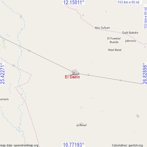
El Daein GPS coordinates[2]
11° 27' 42.696" North, 26° 7' 32.988" East
| Map corner | latitude | longitude |
|---|---|---|
| Upper-left | 12.15011°, | 25.42271° |
| Center: | 11.46186°, | 26.12583° |
| Lower-right: | 10.77193°, | 26.82896° |
| Map W x H: | 153.2×153.2 km | = 95.2×95.2mi |
| max Lat: | 21.06667° ⇑90.1% North |
| El Daein: | 11.46186° |
| min Lat: | ⇓9.9% South 10.55° |
| min Long | El Daein | max Long |
| 22.44725° | 26.12583° | 37.729° |
| W 8.5%⇐ | ⇒91.5% E |
Elevation
Elevation of El Daein is 478 m = 1568 ft, and this is 28.9 m = 95 ft above average elevation for this country.
| Max E: |
1159 m = 3802 ft | 35.2% |
| El Daein | 478 m 1568 ft | |
| Avg. | 449.1 m = 1473 ft | |
Min E: |
4 m = 13 ft | 64.8% |
See also: El Daein elevation on elevation.city.
Geographical zone
El Daein is located in North Torrid zone (between Equator and Tropic of Cancer). Distance of Equator is 1274.4 km =791.9 mi to South.| Distance of | km | miles | from El Daein |
|---|---|---|---|
| North Pole | 8732.6 | 5426.2 | to North |
| Arctic Circle | 6126.7 | 3807 | to North |
| Tropic Cancer | 1331.5 | 827.4 | to North |
| Equator | 1274.4 | 791.9 | to South |


Nearby cities:
14 places around El Daein: (largest is in red/bold)
• Abū Zabad
354 km =220 mi,  73°
73°
• Al Fūlah
245 km =152.2 mi,  82°
82°
• Al Lagowa
327.8 km =203.7 mi,  91°
91°
• Al Mijlad
181.7 km =112.9 mi,  105°
105°
• An Nuhūd
286.2 km =177.8 mi,  61°
61°
• Dilling
389.2 km =241.8 mi, 80°
• El Fasher
255.2 km =158.6 mi,  340°
340°
• El Fula
243.4 km =151.2 mi, 83°
• Gereida
109.4 km =68 mi,  259°
259°
• Kadugli
395 km =245.4 mi,  97°
97°
• Kutum
343.1 km =213.2 mi,  332°
332°
• Nyala
150.4 km =93.5 mi,  295°
295°
• Umm Kaddadah
245.6 km =152.6 mi,  14°
14°
• Zalingei
330.4 km =205.3 mi, 299°
Sources, notices
• [Note1] Compared only with cities in Sudan existing in our database
• [Src1] Map data: © OpenStreetMap contributors (CC-BY-SA)
• [Src2] Other city data from geonames.org with taken over terms of usage.
• [Src3] Geographical zone / Annual Mean Temperature by Robert A. Rohde @ Wikipedia
