Al Mijlad geodata
Al Mijlad (West Kordofan State) is a populated place; located in Sudan in Africa/Khartoum (GMT+2) time zone. With population of 19,997 people, there are 39 cities with bigger population in this country. Compared to other cities in Sudan, 95.8% of cities are located further ↑North; 88.7% of cities are located further →East and 52.1% of cities have lower elevation than Al Mijlad. Note1


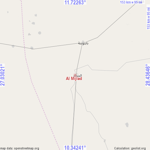
Al Mijlad GPS coordinates[2]
11° 1' 59.988" North, 27° 43' 59.988" East
| Map corner | latitude | longitude |
|---|---|---|
| Upper-left | 11.72263°, | 27.03021° |
| Center: | 11.03333°, | 27.73333° |
| Lower-right: | 10.34241°, | 28.43646° |
| Map W x H: | 153.5×153.5 km | = 95.4×95.4mi |
| max Lat: | 21.06667° ⇑95.8% North |
| Al Mijlad: | 11.03333° |
| min Lat: | ⇓4.2% South 10.55° |
| min Long | Al Mijlad | max Long |
| 22.44725° | 27.73333° | 37.729° |
| W 11.3%⇐ | ⇒88.7% E |
Elevation
Elevation of Al Mijlad is 434 m = 1424 ft, and this is 15.1 m = 50 ft below average elevation for this country.
| Max E: |
1159 m = 3802 ft | 47.9% |
| Avg. | 449.1 m = 1473 ft | |
| Al Mijlad | 434 m = 1424 ft | |
Min E: |
4 m = 13 ft | 52.1% |
See also: Sudan elevation on elevation.city.
Geographical zone
Al Mijlad is located in North Torrid zone (between Equator and Tropic of Cancer). Distance of Equator is 1226.8 km =762.3 mi to South.| Distance of | km | miles | from Al Mijlad |
|---|---|---|---|
| North Pole | 8780.3 | 5455.8 | to North |
| Arctic Circle | 6174.4 | 3836.6 | to North |
| Tropic Cancer | 1379.1 | 856.9 | to North |
| Equator | 1226.8 | 762.3 | to South |


Nearby cities:
15 places around Al Mijlad: (largest is in red/bold)
• Abu Jibeha
384.1 km =238.7 mi,  82°
82°
• Abū Zabad
220.7 km =137.1 mi,  48°
48°
• Al Fūlah
103.4 km =64.2 mi,  41°
41°
• Al Lagowa
158 km =98.2 mi, 75°
• An Nuhūd
200.4 km =124.5 mi,  22°
22°
• Ar Rahad
368.4 km =228.9 mi,  59°
59°
• Dilling
237.4 km =147.5 mi, 61°
• El Daein
181.7 km =112.9 mi,  285°
285°
• El Fula
100.8 km =62.6 mi, 41°
• El Obeid
360.7 km =224.1 mi, 48°
• Gereida
284.2 km =176.6 mi,  275°
275°
• Kadugli
216.7 km =134.7 mi,  90°
90°
• Nyala
330.6 km =205.4 mi, 289°
• Talodi
292.4 km =181.7 mi,  98°
98°
• Umm Kaddadah
307.3 km =190.9 mi,  338°
338°
Sources, notices
• [Note1] Compared only with cities in Sudan existing in our database
• [Src1] Map data: © OpenStreetMap contributors (CC-BY-SA)
• [Src2] Other city data from geonames.org with taken over terms of usage.
• [Src3] Geographical zone / Annual Mean Temperature by Robert A. Rohde @ Wikipedia
