Umm Kaddadah geodata
Umm Kaddadah (Northern Darfur) is a populated place; located in Sudan in Africa/Khartoum (GMT+2) time zone. With population of 10,979 people, there are 58 cities with bigger population in this country. Compared to other cities in Sudan, 53.5% of cities are located further ↑North; 90.1% of cities are located further →East and 85.9% of cities have lower elevation than Umm Kaddadah. Note1


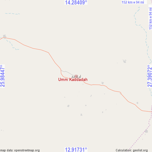
Umm Kaddadah GPS coordinates[2]
13° 36' 6.084" North, 26° 41' 15.324" East
| Map corner | latitude | longitude |
|---|---|---|
| Upper-left | 14.28409°, | 25.98447° |
| Center: | 13.60169°, | 26.68759° |
| Lower-right: | 12.91731°, | 27.39072° |
| Map W x H: | 152×152 km | = 94.4×94.4mi |
| max Lat: | 21.06667° ⇑53.5% North |
| Umm Kaddadah: | 13.60169° |
| min Lat: | ⇓46.5% South 10.55° |
| min Long | Umm Kaddadah | max Long |
| 22.44725° | 26.68759° | 37.729° |
| W 9.9%⇐ | ⇒90.1% E |
Elevation
Elevation of Umm Kaddadah is 601 m = 1972 ft, and this is 151.9 m = 498 ft above average elevation for this country.
| Max E: |
1159 m = 3802 ft | 14.1% |
| Umm Kaddadah | 601 m 1972 ft | |
| Avg. | 449.1 m = 1473 ft | |
Min E: |
4 m = 13 ft | 85.9% |
See also: Sudan elevation on elevation.city.
Geographical zone
Umm Kaddadah is located in North Torrid zone (between Equator and Tropic of Cancer). Distance of this Northern Tropic circle is 1093.6 km =679.5 mi to North.| Distance of | km | miles | from Umm Kaddadah |
|---|---|---|---|
| North Pole | 8494.7 | 5278.4 | to North |
| Arctic Circle | 5888.8 | 3659.1 | to North |
| Tropic Cancer | 1093.6 | 679.5 | to North |
| Equator | 1512.4 | 939.8 | to South |


Nearby cities:
15 places around Umm Kaddadah: (largest is in red/bold)
• Abū Zabad
310.6 km =193 mi,  116°
116°
• Al Fūlah
275.7 km =171.3 mi,  138°
138°
• Al Lagowa
361.1 km =224.4 mi,  132°
132°
• Al Mijlad
307.3 km =190.9 mi,  158°
158°
• An Nuhūd
214 km =133 mi, 117°
• Bārah
397.7 km =247.1 mi,  88°
88°
• Dilling
364.6 km =226.6 mi, 118°
• El Daein
245.6 km =152.6 mi,  194°
194°
• El Fasher
144.6 km =89.9 mi,  271°
271°
• El Fula
276.6 km =171.9 mi, 139°
• El Obeid
384.5 km =238.9 mi,  96°
96°
• Gereida
308.4 km =191.6 mi,  213°
213°
• Kutum
228 km =141.7 mi,  286°
286°
• Nyala
261.1 km =162.2 mi,  228°
228°
• Zalingei
356.6 km =221.6 mi,  257°
257°
Sources, notices
• [Note1] Compared only with cities in Sudan existing in our database
• [Src1] Map data: © OpenStreetMap contributors (CC-BY-SA)
• [Src2] Other city data from geonames.org with taken over terms of usage.
• [Src3] Geographical zone / Annual Mean Temperature by Robert A. Rohde @ Wikipedia
