Virserum geodata
Virserum (Kalmar) is a populated place; located in Sweden in Europe/Stockholm (GMT+2) time zone. With population of 1,769 people, there are 577 cities with bigger population in this country. Compared to other cities in Sweden, 74.6% of cities are located further ↑North; 56.6% of cities are located further ←West and 77.1% of cities have lower elevation than Virserum. Note1


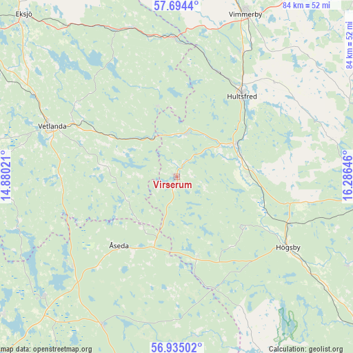
Virserum GPS coordinates[2]
57° 19' 0.012" North, 15° 34' 59.988" East
| Map corner | latitude | longitude |
|---|---|---|
| Upper-left | 57.6944°, | 14.88021° |
| Center: | 57.31667°, | 15.58333° |
| Lower-right: | 56.93502°, | 16.28646° |
| Map W x H: | 84.4×84.4 km | = 52.4×52.4mi |
| max Lat: | 67.85572° ⇑74.6% North |
| Virserum: | 57.31667° |
| min Lat: | ⇓25.4% South 55.34337° |
| min Long | Virserum | max Long |
| 11.1712° | 15.58333° | 24.13676° |
| W 56.6%⇐ | ⇒43.4% E |
Elevation
Elevation of Virserum is 129 m = 423 ft, and this is 46.4 m = 152 ft above average elevation for this country.
| Max E: |
663 m = 2175 ft | 22.9% |
| Virserum | 129 m 423 ft | |
| Avg. | 82.6 m = 271 ft | |
Min E: |
-1 m = -3 ft | 77.1% |
See also: Sweden elevation on elevation.city.
Geographical zone
Virserum is located in North temperate zone (between Tropic of Cancer and the Arctic Circle). Distance of this North polar circle is 1028.2 km =638.9 mi to North.| Distance of | km | miles | from Virserum |
|---|---|---|---|
| North Pole | 3634 | 2258.1 | to North |
| Arctic Circle | 1028.2 | 638.9 | to North |
| Tropic Cancer | 3767.1 | 2340.8 | to South |
| Equator | 6373 | 3960 | to South |


Nearby cities:
15 places around Virserum: (largest is in red/bold)
• Berga
29.3 km =18.2 mi,  112°
112°
• Holsbybrunn
26.4 km =16.4 mi,  299°
299°
• Hultsfred
24.6 km =15.3 mi,  39°
39°
• Hällaryd
30 km =18.6 mi, 303°
• Högsby
31.4 km =19.5 mi,  122°
122°
• Järnforsen
11.3 km =7 mi,  10°
10°
• Korsberga
27.6 km =17.1 mi,  266°
266°
• Mariannelund
33.4 km =20.8 mi,  358°
358°
• Målilla
15.6 km =9.7 mi,  59°
59°
• Mörlunda
16 km =9.9 mi,  90°
90°
• Silverdalen
26.9 km =16.7 mi,  21°
21°
• Skruv
31.2 km =19.4 mi,  233°
233°
• Storebro
33.7 km =20.9 mi,  28°
28°
• Vetlanda
32.8 km =20.4 mi,  292°
292°
• Åseda
21.7 km =13.5 mi,  221°
221°
Sources, notices
• [Note1] Compared only with cities in Sweden existing in our database
• [Src1] Map data: © OpenStreetMap contributors (CC-BY-SA)
• [Src2] Other city data from geonames.org with taken over terms of usage.
• [Src3] Geographical zone / Annual Mean Temperature by Robert A. Rohde @ Wikipedia
