Sjötorp geodata
Sjötorp (Värmland) is a populated place; located in Sweden in Europe/Stockholm (GMT+2) time zone. With population of 551 people, there are 1232 cities with bigger population in this country. Compared to other cities in Sweden, 66.1% of cities are located further ↓South; 60.2% of cities are located further →East and 86.7% of cities have lower elevation than Sjötorp. Note1


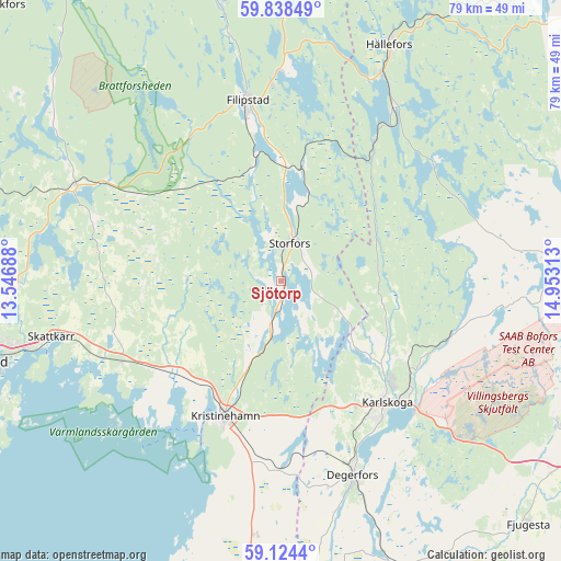
Sjötorp GPS coordinates[2]
59° 28' 59.988" North, 14° 15' 0" East
| Map corner | latitude | longitude |
|---|---|---|
| Upper-left | 59.83849°, | 13.54688° |
| Center: | 59.48333°, | 14.25° |
| Lower-right: | 59.1244°, | 14.95313° |
| Map W x H: | 79.4×79.4 km | = 49.3×49.3mi |
| max Lat: | 67.85572° ⇑33.9% North |
| Sjötorp: | 59.48333° |
| min Lat: | ⇓66.1% South 55.34337° |
| min Long | Sjötorp | max Long |
| 11.1712° | 14.25° | 24.13676° |
| W 39.8%⇐ | ⇒60.2% E |
Elevation
Elevation of Sjötorp is 176 m = 577 ft, and this is 93.4 m = 306 ft above average elevation for this country.
| Max E: |
663 m = 2175 ft | 13.3% |
| Sjötorp | 176 m 577 ft | |
| Avg. | 82.6 m = 271 ft | |
Min E: |
-1 m = -3 ft | 86.7% |
See also: Sweden elevation on elevation.city.
Geographical zone
Sjötorp is located in North temperate zone (between Tropic of Cancer and the Arctic Circle). Distance of this North polar circle is 787.2 km =489.1 mi to North.| Distance of | km | miles | from Sjötorp |
|---|---|---|---|
| North Pole | 3393.1 | 2108.4 | to North |
| Arctic Circle | 787.2 | 489.1 | to North |
| Tropic Cancer | 4008 | 2490.5 | to South |
| Equator | 6613.9 | 4109.7 | to South |


Nearby cities:
15 places around Sjötorp: (largest is in red/bold)
• Alster
37.2 km =23.1 mi,  255°
255°
• Björneborg
26.9 km =16.7 mi,  180°
180°
• Degerfors
29.1 km =18.1 mi,  159°
159°
• Filipstad
25.9 km =16.1 mi,  349°
349°
• Grythyttan
29.5 km =18.3 mi,  32°
32°
• Gyttorp
40.5 km =25.2 mi,  86°
86°
• Hällefors
36.7 km =22.8 mi,  24°
24°
• Karlskoga
23.3 km =14.5 mi,  138°
138°
• Kristinehamn
20.9 km =13 mi,  202°
202°
• Molkom
32.5 km =20.2 mi,  293°
293°
• Nykroppa
15.8 km =9.8 mi,  10°
10°
• Skattkärr
33.7 km =20.9 mi, 256°
• Storfors
5.5 km =3.4 mi, 12°
• Vallargärdet
37.6 km =23.4 mi,  269°
269°
• Väse
25.2 km =15.7 mi,  243°
243°
Sources, notices
• [Note1] Compared only with cities in Sweden existing in our database
• [Src1] Map data: © OpenStreetMap contributors (CC-BY-SA)
• [Src2] Other city data from geonames.org with taken over terms of usage.
• [Src3] Geographical zone / Annual Mean Temperature by Robert A. Rohde @ Wikipedia
