Kristinehamn geodata
Kristinehamn (Värmland) is a seat of a second-order administrative division; located in Sweden in Europe/Stockholm (GMT+2) time zone. With population of 18,557 people, there are 84 cities with bigger population in this country. Compared to other cities in Sweden, 60.1% of cities are located further ↓South; 62.8% of cities are located further →East and 52.7% of cities have lower elevation than Kristinehamn. Note1


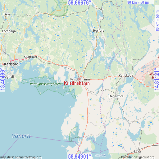
Kristinehamn GPS coordinates[2]
59° 18' 35.208" North, 14° 6' 29.088" East
| Map corner | latitude | longitude |
|---|---|---|
| Upper-left | 59.66676°, | 13.40496° |
| Center: | 59.30978°, | 14.10808° |
| Lower-right: | 58.94901°, | 14.81121° |
| Map W x H: | 79.8×79.8 km | = 49.6×49.6mi |
| max Lat: | 67.85572° ⇑39.9% North |
| Kristinehamn: | 59.30978° |
| min Lat: | ⇓60.1% South 55.34337° |
| min Long | Kristinehamn | max Long |
| 11.1712° | 14.10808° | 24.13676° |
| W 37.2%⇐ | ⇒62.8% E |
Elevation
Elevation of Kristinehamn is 55 m = 180 ft, and this is 27.6 m = 91 ft below average elevation for this country.
| Max E: |
663 m = 2175 ft | 47.3% |
| Avg. | 82.6 m = 271 ft | |
| Kristinehamn | 55 m = 180 ft | |
Min E: |
-1 m = -3 ft | 52.7% |
See also: Sweden elevation on elevation.city.
Geographical zone
Kristinehamn is located in North temperate zone (between Tropic of Cancer and the Arctic Circle). Distance of this North polar circle is 806.5 km =501.1 mi to North.| Distance of | km | miles | from Kristinehamn |
|---|---|---|---|
| North Pole | 3412.4 | 2120.4 | to North |
| Arctic Circle | 806.5 | 501.1 | to North |
| Tropic Cancer | 3988.7 | 2478.5 | to South |
| Equator | 6594.6 | 4097.7 | to South |


Nearby cities:
15 places around Kristinehamn: (largest is in red/bold)
• Alster
29.7 km =18.5 mi,  289°
289°
• Baggetorp
34.8 km =21.6 mi,  120°
120°
• Björneborg
11.1 km =6.9 mi,  133°
133°
• Degerfors
20 km =12.4 mi,  113°
113°
• Gullspång
36 km =22.4 mi,  181°
181°
• Karlskoga
23.7 km =14.7 mi,  85°
85°
• Karlstad
35.1 km =21.8 mi,  282°
282°
• Nykroppa
36.5 km =22.7 mi,  17°
17°
• Råtorp
36.4 km =22.6 mi, 286°
• Sjötorp
20.9 km =13 mi, 22°
• Skattkärr
27.3 km =17 mi, 294°
• Skoghall
36.5 km =22.7 mi,  272°
272°
• Storfors
26.4 km =16.4 mi, 20°
• Vallargärdet
35 km =21.7 mi,  302°
302°
• Väse
16.7 km =10.4 mi, 299°
Sources, notices
• [Note1] Compared only with cities in Sweden existing in our database
• [Src1] Map data: © OpenStreetMap contributors (CC-BY-SA)
• [Src2] Other city data from geonames.org with taken over terms of usage.
• [Src3] Geographical zone / Annual Mean Temperature by Robert A. Rohde @ Wikipedia
