Vittangi geodata
Vittangi (Norrbotten) is a populated place; located in Sweden in Europe/Stockholm (GMT+2) time zone. With population of 791 people, there are 970 cities with bigger population in this country. Compared to other cities in Sweden, 99.8% of cities are located further ↓South; 97.9% of cities are located further ←West and 94.6% of cities have lower elevation than Vittangi. Note1


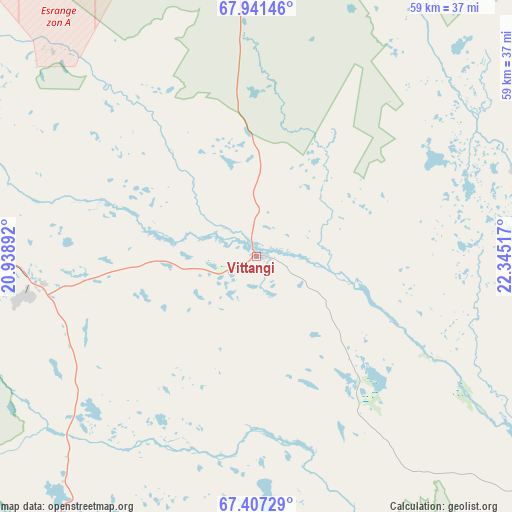
Vittangi GPS coordinates[2]
67° 40' 33.204" North, 21° 38' 31.344" East
| Map corner | latitude | longitude |
|---|---|---|
| Upper-left | 67.94146°, | 20.93892° |
| Center: | 67.67589°, | 21.64204° |
| Lower-right: | 67.40729°, | 22.34517° |
| Map W x H: | 59.4×59.4 km | = 36.9×36.9mi |
| max Lat: | 67.85572° ⇑0.2% North |
| Vittangi: | 67.67589° |
| min Lat: | ⇓99.8% South 55.34337° |
| min Long | Vittangi | max Long |
| 11.1712° | 21.64204° | 24.13676° |
| W 97.9%⇐ | ⇒2.1% E |
Elevation
Elevation of Vittangi is 252 m = 827 ft, and this is 169.4 m = 556 ft above average elevation for this country.
| Max E: |
663 m = 2175 ft | 5.4% |
| Vittangi | 252 m 827 ft | |
| Avg. | 82.6 m = 271 ft | |
Min E: |
-1 m = -3 ft | 94.6% |
See also: Sweden elevation on elevation.city.
Geographical zone
Vittangi is located in North Frigid zone (between North Pole and Arctic Circle). Distance of this North polar circle is 123.7 km =76.9 mi to South.| Distance of | km | miles | from Vittangi |
|---|---|---|---|
| North Pole | 2482.2 | 1542.4 | to North |
| Arctic Circle | 123.7 | 76.9 | to South |
| Tropic Cancer | 4918.9 | 3056.5 | to South |
| Equator | 7524.9 | 4675.8 | to South |


Nearby cities:
15 places around Vittangi: (largest is in red/bold)
• Gällivare
73.6 km =45.7 mi,  215°
215°
• Jokkmokk
142.5 km =88.5 mi,  213°
213°
• Jukkasjärvi
47.3 km =29.4 mi,  294°
294°
• Kiruna
62.9 km =39.1 mi, 288°
• Korpilombolo
109.9 km =68.3 mi,  146°
146°
• Koskullskulle
66.7 km =41.4 mi, 214°
• Långvik
175.3 km =108.9 mi,  171°
171°
• Malmberget
69.8 km =43.4 mi, 217°
• Pajala
89.8 km =55.8 mi,  125°
125°
• Råneå
204.5 km =127.1 mi, 171°
• Tuolluvaara
58.4 km =36.3 mi, 289°
• Töre
201 km =124.9 mi, 167°
• Vuollerim
145.3 km =90.3 mi,  197°
197°
• Överkalix
158.7 km =98.6 mi,  160°
160°
• Övertorneå
167.7 km =104.2 mi, 148°
Sources, notices
• [Note1] Compared only with cities in Sweden existing in our database
• [Src1] Map data: © OpenStreetMap contributors (CC-BY-SA)
• [Src2] Other city data from geonames.org with taken over terms of usage.
• [Src3] Geographical zone / Annual Mean Temperature by Robert A. Rohde @ Wikipedia
