Koskullskulle geodata
Koskullskulle (Norrbotten) is a populated place; located in Sweden in Europe/Stockholm (GMT+2) time zone. With population of 818 people, there are 948 cities with bigger population in this country. Compared to other cities in Sweden, 99.6% of cities are located further ↓South; 95.9% of cities are located further ←West and 96% of cities have lower elevation than Koskullskulle. Note1


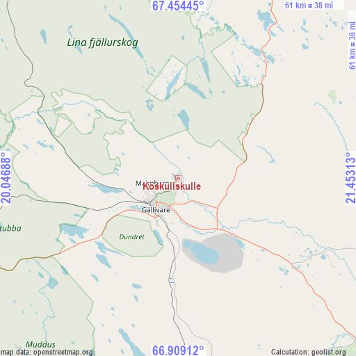
Koskullskulle GPS coordinates[2]
67° 10' 59.988" North, 20° 45' 0" East
| Map corner | latitude | longitude |
|---|---|---|
| Upper-left | 67.45445°, | 20.04688° |
| Center: | 67.18333°, | 20.75° |
| Lower-right: | 66.90912°, | 21.45313° |
| Map W x H: | 60.6×60.6 km | = 37.7×37.7mi |
| max Lat: | 67.85572° ⇑0.4% North |
| Koskullskulle: | 67.18333° |
| min Lat: | ⇓99.6% South 55.34337° |
| min Long | Koskullskulle | max Long |
| 11.1712° | 20.75° | 24.13676° |
| W 95.9%⇐ | ⇒4.1% E |
Elevation
Elevation of Koskullskulle is 297 m = 974 ft, and this is 214.4 m = 703 ft above average elevation for this country.
| Max E: |
663 m = 2175 ft | 4% |
| Koskullskulle | 297 m 974 ft | |
| Avg. | 82.6 m = 271 ft | |
Min E: |
-1 m = -3 ft | 96% |
See also: Sweden elevation on elevation.city.
Geographical zone
Koskullskulle is located in North Frigid zone (between North Pole and Arctic Circle). Distance of this North polar circle is 68.9 km =42.8 mi to South.| Distance of | km | miles | from Koskullskulle |
|---|---|---|---|
| North Pole | 2537 | 1576.4 | to North |
| Arctic Circle | 68.9 | 42.8 | to South |
| Tropic Cancer | 4864.2 | 3022.5 | to South |
| Equator | 7470.1 | 4641.7 | to South |


Nearby cities:
15 places around Koskullskulle: (largest is in red/bold)
• Boden
156.6 km =97.3 mi,  164°
164°
• Gällivare
6.9 km =4.3 mi,  217°
217°
• Jokkmokk
75.8 km =47.1 mi,  212°
212°
• Jukkasjärvi
74.3 km =46.2 mi,  355°
355°
• Kiruna
78 km =48.5 mi,  343°
343°
• Korpilombolo
106.6 km =66.2 mi,  110°
110°
• Långvik
135.4 km =84.1 mi,  151°
151°
• Malmberget
4.2 km =2.6 mi,  257°
257°
• Pajala
112.8 km =70.1 mi,  88°
88°
• Tuolluvaara
76.2 km =47.3 mi,  346°
346°
• Vidsel
150.2 km =93.3 mi,  183°
183°
• Vittangi
66.7 km =41.4 mi,  34°
34°
• Vuollerim
83.9 km =52.1 mi, 183°
• Överkalix
132.3 km =82.2 mi,  136°
136°
• Övertorneå
155 km =96.3 mi,  124°
124°
Sources, notices
• [Note1] Compared only with cities in Sweden existing in our database
• [Src1] Map data: © OpenStreetMap contributors (CC-BY-SA)
• [Src2] Other city data from geonames.org with taken over terms of usage.
• [Src3] Geographical zone / Annual Mean Temperature by Robert A. Rohde @ Wikipedia
