Malmberget geodata
Malmberget (Norrbotten) is a populated place; located in Sweden in Europe/Stockholm (GMT+2) time zone. With population of 6,017 people, there are 235 cities with bigger population in this country. Compared to other cities in Sweden, 99.5% of cities are located further ↓South; 95.7% of cities are located further ←West and 99.1% of cities have lower elevation than Malmberget. Note1


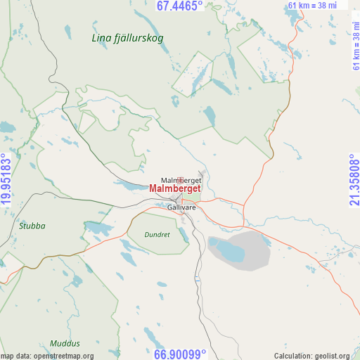
Malmberget GPS coordinates[2]
67° 10' 31.044" North, 20° 39' 17.82" East
| Map corner | latitude | longitude |
|---|---|---|
| Upper-left | 67.4465°, | 19.95183° |
| Center: | 67.17529°, | 20.65495° |
| Lower-right: | 66.90099°, | 21.35808° |
| Map W x H: | 60.7×60.7 km | = 37.7×37.7mi |
| max Lat: | 67.85572° ⇑0.5% North |
| Malmberget: | 67.17529° |
| min Lat: | ⇓99.5% South 55.34337° |
| min Long | Malmberget | max Long |
| 11.1712° | 20.65495° | 24.13676° |
| W 95.7%⇐ | ⇒4.3% E |
Elevation
Elevation of Malmberget is 418 m = 1371 ft, and this is 335.4 m = 1100 ft above average elevation for this country.
| Max E: |
663 m = 2175 ft | 0.90000000000001% |
| Malmberget | 418 m 1371 ft | |
| Avg. | 82.6 m = 271 ft | |
Min E: |
-1 m = -3 ft | 99.1% |
See also: Sweden elevation on elevation.city.
Geographical zone
Malmberget is located in North Frigid zone (between North Pole and Arctic Circle). Distance of this North polar circle is 68 km =42.3 mi to South.| Distance of | km | miles | from Malmberget |
|---|---|---|---|
| North Pole | 2537.9 | 1577 | to North |
| Arctic Circle | 68 | 42.3 | to South |
| Tropic Cancer | 4863.3 | 3021.9 | to South |
| Equator | 7469.2 | 4641.1 | to South |


Nearby cities:
15 places around Malmberget: (largest is in red/bold)
• Boden
157 km =97.6 mi,  163°
163°
• Gällivare
4.6 km =2.9 mi,  181°
181°
• Jokkmokk
72.9 km =45.3 mi,  209°
209°
• Jukkasjärvi
75 km =46.6 mi,  358°
358°
• Kiruna
77.8 km =48.3 mi,  346°
346°
• Korpilombolo
110.2 km =68.5 mi,  109°
109°
• Koskullskulle
4.2 km =2.6 mi,  77°
77°
• Långvik
136.7 km =84.9 mi,  149°
149°
• Pajala
116.9 km =72.6 mi,  87°
87°
• Tuolluvaara
76.3 km =47.4 mi, 349°
• Vidsel
149.1 km =92.6 mi, 182°
• Vittangi
69.8 km =43.4 mi,  37°
37°
• Vuollerim
82.8 km =51.4 mi, 180°
• Överkalix
134.6 km =83.6 mi,  134°
134°
• Övertorneå
157.9 km =98.1 mi,  123°
123°
Sources, notices
• [Note1] Compared only with cities in Sweden existing in our database
• [Src1] Map data: © OpenStreetMap contributors (CC-BY-SA)
• [Src2] Other city data from geonames.org with taken over terms of usage.
• [Src3] Geographical zone / Annual Mean Temperature by Robert A. Rohde @ Wikipedia
