Pajala geodata
Pajala (Norrbotten) is a seat of a second-order administrative division; located in Sweden in Europe/Stockholm (GMT+2) time zone. With population of 2,032 people, there are 516 cities with bigger population in this country. Compared to other cities in Sweden, 99.7% of cities are located further ↓South; 99.7% of cities are located further ←West and 86.1% of cities have lower elevation than Pajala. Note1


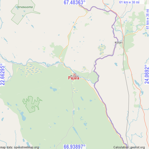
Pajala GPS coordinates[2]
67° 12' 46.224" North, 23° 21' 57.852" East
| Map corner | latitude | longitude |
|---|---|---|
| Upper-left | 67.48363°, | 22.66295° |
| Center: | 67.21284°, | 23.36607° |
| Lower-right: | 66.93897°, | 24.0692° |
| Map W x H: | 60.6×60.6 km | = 37.7×37.7mi |
| max Lat: | 67.85572° ⇑0.3% North |
| Pajala: | 67.21284° |
| min Lat: | ⇓99.7% South 55.34337° |
| min Long | Pajala | max Long |
| 11.1712° | 23.36607° | 24.13676° |
| W 99.7%⇐ | ⇒0.3% E |
Elevation
Elevation of Pajala is 173 m = 568 ft, and this is 90.4 m = 297 ft above average elevation for this country.
| Max E: |
663 m = 2175 ft | 13.9% |
| Pajala | 173 m 568 ft | |
| Avg. | 82.6 m = 271 ft | |
Min E: |
-1 m = -3 ft | 86.1% |
See also: Sweden elevation on elevation.city.
Geographical zone
Pajala is located in North Frigid zone (between North Pole and Arctic Circle). Distance of this North polar circle is 72.2 km =44.9 mi to South.| Distance of | km | miles | from Pajala |
|---|---|---|---|
| North Pole | 2533.7 | 1574.4 | to North |
| Arctic Circle | 72.2 | 44.9 | to South |
| Tropic Cancer | 4867.4 | 3024.5 | to South |
| Equator | 7473.4 | 4643.8 | to South |


Nearby cities:
15 places around Pajala: (largest is in red/bold)
• Gällivare
117.4 km =72.9 mi,  265°
265°
• Jukkasjärvi
136.6 km =84.9 mi,  301°
301°
• Kalix
151.5 km =94.1 mi,  183°
183°
• Kiruna
151.4 km =94.1 mi, 298°
• Korpilombolo
42.4 km =26.3 mi,  198°
198°
• Koskullskulle
112.8 km =70.1 mi, 268°
• Långvik
131.7 km =81.8 mi, 202°
• Malmberget
116.9 km =72.6 mi, 267°
• Sangis
151 km =93.8 mi, 177°
• Tuolluvaara
147 km =91.3 mi, 298°
• Töre
148 km =92 mi,  192°
192°
• Vittangi
89.8 km =55.8 mi,  305°
305°
• Vuollerim
148.2 km =92.1 mi,  234°
234°
• Överkalix
101.1 km =62.8 mi, 193°
• Övertorneå
92.6 km =57.5 mi,  172°
172°
Sources, notices
• [Note1] Compared only with cities in Sweden existing in our database
• [Src1] Map data: © OpenStreetMap contributors (CC-BY-SA)
• [Src2] Other city data from geonames.org with taken over terms of usage.
• [Src3] Geographical zone / Annual Mean Temperature by Robert A. Rohde @ Wikipedia
