Tuolluvaara geodata
Tuolluvaara (Norrbotten) is a populated place; located in Sweden in Europe/Stockholm (GMT+2) time zone. With population of 979 people, there are 832 cities with bigger population in this country. Compared to other cities in Sweden, 99.8% of cities are located further ↓South; 94.7% of cities are located further ←West and 99.8% of cities have lower elevation than Tuolluvaara. Note1


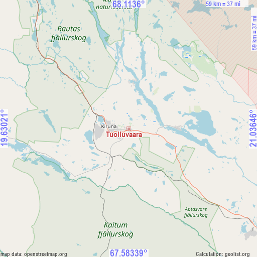
Tuolluvaara GPS coordinates[2]
67° 51' 0" North, 20° 19' 59.988" East
| Map corner | latitude | longitude |
|---|---|---|
| Upper-left | 68.1136°, | 19.63021° |
| Center: | 67.85°, | 20.33333° |
| Lower-right: | 67.58339°, | 21.03646° |
| Map W x H: | 59×59 km | = 36.7×36.7mi |
| max Lat: | 67.85572° ⇑0.2% North |
| Tuolluvaara: | 67.85° |
| min Lat: | ⇓99.8% South 55.34337° |
| min Long | Tuolluvaara | max Long |
| 11.1712° | 20.33333° | 24.13676° |
| W 94.7%⇐ | ⇒5.3% E |
Elevation
Elevation of Tuolluvaara is 448 m = 1470 ft, and this is 365.4 m = 1199 ft above average elevation for this country.
| Max E: |
663 m = 2175 ft | 0.2% |
| Tuolluvaara | 448 m 1470 ft | |
| Avg. | 82.6 m = 271 ft | |
Min E: |
-1 m = -3 ft | 99.8% |
See also: Sweden elevation on elevation.city.
Geographical zone
Tuolluvaara is located in North Frigid zone (between North Pole and Arctic Circle). Distance of this North polar circle is 143 km =88.9 mi to South.| Distance of | km | miles | from Tuolluvaara |
|---|---|---|---|
| North Pole | 2462.8 | 1530.3 | to North |
| Arctic Circle | 143 | 88.9 | to South |
| Tropic Cancer | 4938.3 | 3068.5 | to South |
| Equator | 7544.2 | 4687.7 | to South |


Nearby cities:
15 places around Tuolluvaara: (largest is in red/bold)
• Arjeplog
226.5 km =140.7 mi,  208°
208°
• Gällivare
80.8 km =50.2 mi,  170°
170°
• Jokkmokk
140 km =87 mi,  189°
189°
• Jukkasjärvi
11.9 km =7.4 mi,  90°
90°
• Kiruna
4.6 km =2.9 mi,  277°
277°
• Korpilombolo
160.9 km =100 mi,  133°
133°
• Koskullskulle
76.2 km =47.3 mi, 166°
• Långvik
209.7 km =130.3 mi,  156°
156°
• Malmberget
76.3 km =47.4 mi, 169°
• Pajala
147 km =91.3 mi,  118°
118°
• Vidsel
224.2 km =139.3 mi,  177°
177°
• Vittangi
58.4 km =36.3 mi,  109°
109°
• Vuollerim
158.3 km =98.4 mi, 175°
• Överkalix
201.1 km =125 mi,  147°
147°
• Övertorneå
216.8 km =134.7 mi,  138°
138°
Sources, notices
• [Note1] Compared only with cities in Sweden existing in our database
• [Src1] Map data: © OpenStreetMap contributors (CC-BY-SA)
• [Src2] Other city data from geonames.org with taken over terms of usage.
• [Src3] Geographical zone / Annual Mean Temperature by Robert A. Rohde @ Wikipedia
