Makeni geodata
Makeni (Northern Province) is a seat of a first-order administrative division; located in Sierra Leone in Africa/Freetown (GMT+0) time zone. With population of 87,679 people, there are 4 cities with bigger population in this country. Compared to other cities in Sierra Leone, 81.9% of cities are located further ↓South; 68.7% of cities are located further →East and 54.2% of cities have higher elevation than Makeni. Note1


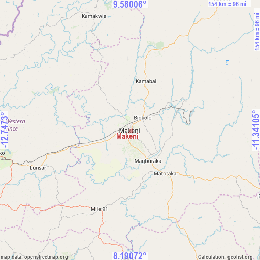
Makeni GPS coordinates[2]
8° 53' 9.78" North, 12° 2' 39.012" West
| Map corner | latitude | longitude |
|---|---|---|
| Upper-left | 9.58006°, | -12.7473° |
| Center: | 8.88605°, | -12.04417° |
| Lower-right: | 8.19072°, | -11.34105° |
| Map W x H: | 154.5×154.5 km | = 96×96mi |
| max Lat: | 9.91376° ⇑18.1% North |
| Makeni: | 8.88605° |
| min Lat: | ⇓81.9% South 7.24611° |
| min Long | Makeni | max Long |
| -13.28972° | -12.04417° | -10.37135° |
| W 31.3%⇐ | ⇒68.7% E |
Elevation
Elevation of Makeni is 93 m = 305 ft, and this is 64.2 m = 211 ft below average elevation for this country.
| Max E: |
564 m = 1850 ft | 54.2% |
| Avg. | 157.2 m = 516 ft | |
| Makeni | 93 m = 305 ft | |
Min E: |
1 m = 3 ft | 45.8% |
See also: Makeni elevation on elevation.city.
Geographical zone
Makeni is located in North Torrid zone (between Equator and Tropic of Cancer). Distance of Equator is 988 km =613.9 mi to South.| Distance of | km | miles | from Makeni |
|---|---|---|---|
| North Pole | 9019 | 5604.1 | to North |
| Arctic Circle | 6413.1 | 3984.9 | to North |
| Tropic Cancer | 1617.9 | 1005.3 | to North |
| Equator | 988 | 613.9 | to South |


Nearby cities:
15 places around Makeni: (largest is in red/bold)
• Alikalia
78 km =48.5 mi,  67°
67°
• Baiima
89.1 km =55.4 mi,  165°
165°
• Binkolo
10.2 km =6.3 mi,  43°
43°
• Bumbuna
37.2 km =23.1 mi,  61°
61°
• Kamakwie
71.3 km =44.3 mi,  342°
342°
• Kukuna
88.8 km =55.2 mi,  309°
309°
• Largo
68.6 km =42.6 mi,  190°
190°
• Lunsar
58.4 km =36.3 mi,  247°
247°
• Magburaka
20.9 km =13 mi,  149°
149°
• Makali
50.8 km =31.6 mi,  124°
124°
• Masaka
36.2 km =22.5 mi,  132°
132°
• Masingbi
15.4 km =9.6 mi,  138°
138°
• Port Loko
82.7 km =51.4 mi,  260°
260°
• Rokupr
44.4 km =27.6 mi,  237°
237°
• Yonibana
53.7 km =33.4 mi,  203°
203°
Sources, notices
• [Note1] Compared only with cities in Sierra Leone existing in our database
• [Src1] Map data: © OpenStreetMap contributors (CC-BY-SA)
• [Src2] Other city data from geonames.org with taken over terms of usage.
• [Src3] Geographical zone / Annual Mean Temperature by Robert A. Rohde @ Wikipedia
