Magburaka geodata
Magburaka (Northern Province) is a populated place; located in Sierra Leone in Africa/Freetown (GMT+0) time zone. With population of 14,915 people, there are 10 cities with bigger population in this country. Compared to other cities in Sierra Leone, 78.3% of cities are located further ↓South; 62.7% of cities are located further →East and 53% of cities have higher elevation than Magburaka. Note1


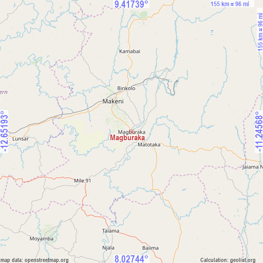
Magburaka GPS coordinates[2]
8° 43' 23.016" North, 11° 56' 55.68" West
| Map corner | latitude | longitude |
|---|---|---|
| Upper-left | 9.41739°, | -12.65193° |
| Center: | 8.72306°, | -11.9488° |
| Lower-right: | 8.02744°, | -11.24568° |
| Map W x H: | 154.5×154.6 km | = 96×96.1mi |
| max Lat: | 9.91376° ⇑21.7% North |
| Magburaka: | 8.72306° |
| min Lat: | ⇓78.3% South 7.24611° |
| min Long | Magburaka | max Long |
| -13.28972° | -11.9488° | -10.37135° |
| W 37.3%⇐ | ⇒62.7% E |
Elevation
Elevation of Magburaka is 99 m = 325 ft, and this is 58.2 m = 191 ft below average elevation for this country.
| Max E: |
564 m = 1850 ft | 53% |
| Avg. | 157.2 m = 516 ft | |
| Magburaka | 99 m = 325 ft | |
Min E: |
1 m = 3 ft | 47% |
See also: Sierra Leone elevation on elevation.city.
Geographical zone
Magburaka is located in North Torrid zone (between Equator and Tropic of Cancer). Distance of Equator is 969.9 km =602.7 mi to South.| Distance of | km | miles | from Magburaka |
|---|---|---|---|
| North Pole | 9037.1 | 5615.4 | to North |
| Arctic Circle | 6431.3 | 3996.2 | to North |
| Tropic Cancer | 1636 | 1016.6 | to North |
| Equator | 969.9 | 602.7 | to South |


Nearby cities:
15 places around Magburaka: (largest is in red/bold)
• Alikalia
78.1 km =48.5 mi,  52°
52°
• Baiima
69.3 km =43.1 mi,  170°
170°
• Barma
79.7 km =49.5 mi,  121°
121°
• Binkolo
25.7 km =16 mi,  352°
352°
• Bumbuna
42.1 km =26.2 mi,  31°
31°
• Largo
54.5 km =33.9 mi,  204°
204°
• Lunsar
64.6 km =40.1 mi,  266°
266°
• Makali
33.2 km =20.6 mi,  108°
108°
• Makeni
20.9 km =13 mi,  329°
329°
• Mamboma
76.3 km =47.4 mi,  157°
157°
• Masaka
17.3 km =10.7 mi, 111°
• Masingbi
6.6 km =4.1 mi,  357°
357°
• Rokupr
48.3 km =30 mi,  263°
263°
• Tefeya
80.9 km =50.3 mi,  91°
91°
• Yonibana
44.6 km =27.7 mi,  225°
225°
Sources, notices
• [Note1] Compared only with cities in Sierra Leone existing in our database
• [Src1] Map data: © OpenStreetMap contributors (CC-BY-SA)
• [Src2] Other city data from geonames.org with taken over terms of usage.
• [Src3] Geographical zone / Annual Mean Temperature by Robert A. Rohde @ Wikipedia
