Masaka geodata
Masaka (Northern Province) is a populated place; located in Sierra Leone in Africa/Freetown (GMT+0) time zone. With population of 3,219 people, there are 71 cities with bigger population in this country. Compared to other cities in Sierra Leone, 69.9% of cities are located further ↓South; 56.6% of cities are located further →East and 57.8% of cities have lower elevation than Masaka. Note1


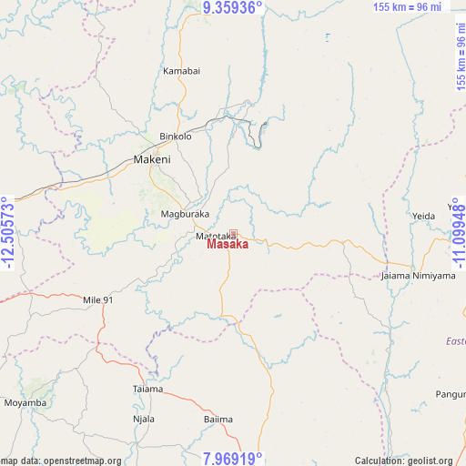
Masaka GPS coordinates[2]
8° 39' 53.712" North, 11° 48' 9.36" West
| Map corner | latitude | longitude |
|---|---|---|
| Upper-left | 9.35936°, | -12.50573° |
| Center: | 8.66492°, | -11.8026° |
| Lower-right: | 7.96919°, | -11.09948° |
| Map W x H: | 154.6×154.6 km | = 96.1×96.1mi |
| max Lat: | 9.91376° ⇑30.1% North |
| Masaka: | 8.66492° |
| min Lat: | ⇓69.9% South 7.24611° |
| min Long | Masaka | max Long |
| -13.28972° | -11.8026° | -10.37135° |
| W 43.4%⇐ | ⇒56.6% E |
Elevation
Elevation of Masaka is 129 m = 423 ft, and this is 28.2 m = 93 ft below average elevation for this country.
| Max E: |
564 m = 1850 ft | 42.2% |
| Avg. | 157.2 m = 516 ft | |
| Masaka | 129 m = 423 ft | |
Min E: |
1 m = 3 ft | 57.8% |
See also: Sierra Leone elevation on elevation.city.
Geographical zone
Masaka is located in North Torrid zone (between Equator and Tropic of Cancer). Distance of Equator is 963.4 km =598.6 mi to South.| Distance of | km | miles | from Masaka |
|---|---|---|---|
| North Pole | 9043.6 | 5619.4 | to North |
| Arctic Circle | 6437.7 | 4000.2 | to North |
| Tropic Cancer | 1642.5 | 1020.6 | to North |
| Equator | 963.4 | 598.6 | to South |


Nearby cities:
15 places around Masaka: (largest is in red/bold)
• Baiima
62.1 km =38.6 mi,  184°
184°
• Barma
62.6 km =38.9 mi,  124°
124°
• Binkolo
37.4 km =23.2 mi,  328°
328°
• Bumbuna
42.7 km =26.5 mi,  8°
8°
• Largo
58 km =36 mi,  222°
222°
• Magburaka
17.3 km =10.7 mi,  291°
291°
• Makali
16 km =9.9 mi,  104°
104°
• Makeni
36.2 km =22.5 mi,  312°
312°
• Mamboma
65.4 km =40.6 mi,  168°
168°
• Masingbi
20.9 km =13 mi, 308°
• Palima
68.8 km =42.8 mi,  151°
151°
• Rokupr
64 km =39.8 mi,  270°
270°
• Tefeya
65 km =40.4 mi,  86°
86°
• Yengema
69.7 km =43.3 mi, 85°
• Yonibana
54 km =33.6 mi,  242°
242°
Sources, notices
• [Note1] Compared only with cities in Sierra Leone existing in our database
• [Src1] Map data: © OpenStreetMap contributors (CC-BY-SA)
• [Src2] Other city data from geonames.org with taken over terms of usage.
• [Src3] Geographical zone / Annual Mean Temperature by Robert A. Rohde @ Wikipedia
