Mamboma geodata
Mamboma (Southern Province) is a populated place; located in Sierra Leone in Africa/Freetown (GMT+0) time zone. With population of 5,201 people, there are 42 cities with bigger population in this country. Compared to other cities in Sierra Leone, 68.7% of cities are located further ↑North; 51.8% of cities are located further ←West and 50.6% of cities have lower elevation than Mamboma. Note1


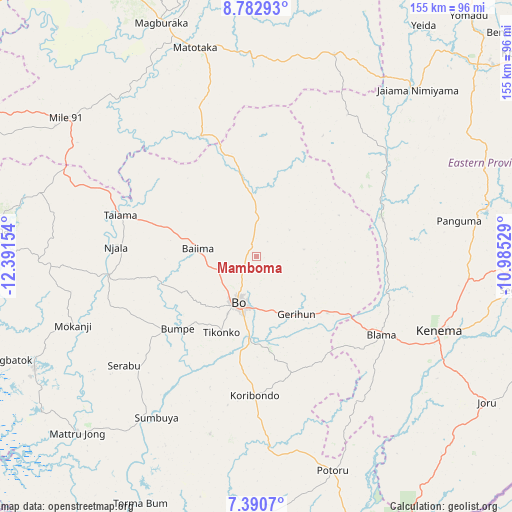
Mamboma GPS coordinates[2]
8° 5' 14.712" North, 11° 41' 18.276" West
| Map corner | latitude | longitude |
|---|---|---|
| Upper-left | 8.78293°, | -12.39154° |
| Center: | 8.08742°, | -11.68841° |
| Lower-right: | 7.3907°, | -10.98529° |
| Map W x H: | 154.8×154.8 km | = 96.2×96.2mi |
| max Lat: | 9.91376° ⇑68.7% North |
| Mamboma: | 8.08742° |
| min Lat: | ⇓31.3% South 7.24611° |
| min Long | Mamboma | max Long |
| -13.28972° | -11.68841° | -10.37135° |
| W 51.8%⇐ | ⇒48.2% E |
Elevation
Elevation of Mamboma is 105 m = 344 ft, and this is 52.2 m = 171 ft below average elevation for this country.
| Max E: |
564 m = 1850 ft | 49.4% |
| Avg. | 157.2 m = 516 ft | |
| Mamboma | 105 m = 344 ft | |
Min E: |
1 m = 3 ft | 50.6% |
See also: Sierra Leone elevation on elevation.city.
Geographical zone
Mamboma is located in North Torrid zone (between Equator and Tropic of Cancer). Distance of Equator is 899.2 km =558.7 mi to South.| Distance of | km | miles | from Mamboma |
|---|---|---|---|
| North Pole | 9107.8 | 5659.3 | to North |
| Arctic Circle | 6501.9 | 4040.1 | to North |
| Tropic Cancer | 1706.7 | 1060.5 | to North |
| Equator | 899.2 | 558.7 | to South |


Nearby cities:
15 places around Mamboma: (largest is in red/bold)
• Baiima
17.7 km =11 mi,  277°
277°
• Baoma
10.8 km =6.7 mi,  195°
195°
• Barma
49 km =30.4 mi,  53°
53°
• Blama
44.6 km =27.7 mi,  122°
122°
• Bo
14.7 km =9.1 mi, 201°
• Boajibu
39.9 km =24.8 mi,  73°
73°
• Bumpe
32.3 km =20.1 mi,  227°
227°
• Gandorhun
59.2 km =36.8 mi,  180°
180°
• Kenema
59.6 km =37 mi,  113°
113°
• Koribundu
42 km =26.1 mi, 180°
• Largo
55.9 km =34.7 mi,  292°
292°
• Palima
20.3 km =12.6 mi,  79°
79°
• Serabu
51.8 km =32.2 mi, 230°
• Sumbuya
57.3 km =35.6 mi,  211°
211°
• Wima
58.3 km =36.2 mi, 66°
Sources, notices
• [Note1] Compared only with cities in Sierra Leone existing in our database
• [Src1] Map data: © OpenStreetMap contributors (CC-BY-SA)
• [Src2] Other city data from geonames.org with taken over terms of usage.
• [Src3] Geographical zone / Annual Mean Temperature by Robert A. Rohde @ Wikipedia
