Baoma geodata
Baoma (Southern Province) is a populated place; located in Sierra Leone in Africa/Freetown (GMT+0) time zone. With population of 7,044 people, there are 31 cities with bigger population in this country. Compared to other cities in Sierra Leone, 71.1% of cities are located further ↑North; 51.8% of cities are located further →East and 51.8% of cities have higher elevation than Baoma. Note1


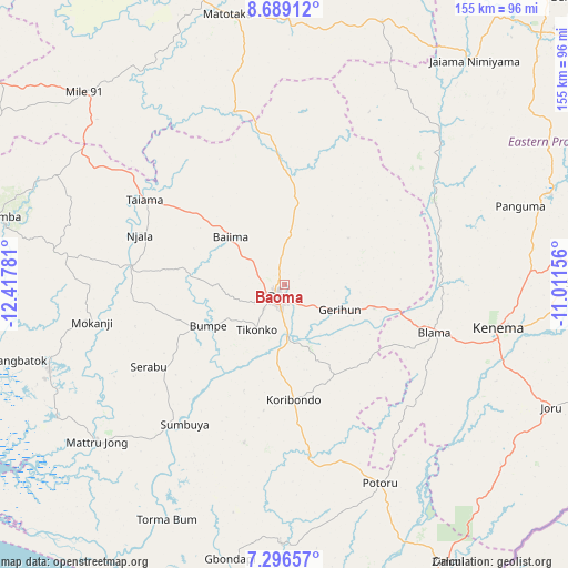
Baoma GPS coordinates[2]
7° 59' 36.384" North, 11° 42' 52.848" West
| Map corner | latitude | longitude |
|---|---|---|
| Upper-left | 8.68912°, | -12.41781° |
| Center: | 7.99344°, | -11.71468° |
| Lower-right: | 7.29657°, | -11.01156° |
| Map W x H: | 154.8×154.8 km | = 96.2×96.2mi |
| max Lat: | 9.91376° ⇑71.1% North |
| Baoma: | 7.99344° |
| min Lat: | ⇓28.9% South 7.24611° |
| min Long | Baoma | max Long |
| -13.28972° | -11.71468° | -10.37135° |
| W 48.2%⇐ | ⇒51.8% E |
Elevation
Elevation of Baoma is 100 m = 328 ft, and this is 57.2 m = 188 ft below average elevation for this country.
| Max E: |
564 m = 1850 ft | 51.8% |
| Avg. | 157.2 m = 516 ft | |
| Baoma | 100 m = 328 ft | |
Min E: |
1 m = 3 ft | 48.2% |
See also: Sierra Leone elevation on elevation.city.
Geographical zone
Baoma is located in North Torrid zone (between Equator and Tropic of Cancer). Distance of Equator is 888.8 km =552.3 mi to South.| Distance of | km | miles | from Baoma |
|---|---|---|---|
| North Pole | 9118.3 | 5665.8 | to North |
| Arctic Circle | 6512.4 | 4046.6 | to North |
| Tropic Cancer | 1717.1 | 1067 | to North |
| Equator | 888.8 | 552.3 | to South |


Nearby cities:
15 places around Baoma: (largest is in red/bold)
• Baiima
19.4 km =12.1 mi,  311°
311°
• Barma
57.9 km =36 mi,  46°
46°
• Blama
42.7 km =26.5 mi,  107°
107°
• Bo
4.1 km =2.5 mi,  219°
219°
• Boajibu
46.5 km =28.9 mi,  62°
62°
• Bumpe
23.8 km =14.8 mi,  241°
241°
• Gandorhun
48.8 km =30.3 mi,  177°
177°
• Gandorhun
56.9 km =35.4 mi,  192°
192°
• Gbewebu
50.6 km =31.4 mi,  166°
166°
• Koribundu
31.7 km =19.7 mi, 175°
• Largo
58.2 km =36.2 mi,  303°
303°
• Mamboma
10.8 km =6.7 mi,  15°
15°
• Palima
26.8 km =16.7 mi, 58°
• Serabu
43.4 km =27 mi, 239°
• Sumbuya
47 km =29.2 mi, 215°
Sources, notices
• [Note1] Compared only with cities in Sierra Leone existing in our database
• [Src1] Map data: © OpenStreetMap contributors (CC-BY-SA)
• [Src2] Other city data from geonames.org with taken over terms of usage.
• [Src3] Geographical zone / Annual Mean Temperature by Robert A. Rohde @ Wikipedia
