Koribundu geodata
Koribundu (Southern Province) is a populated place; located in Sierra Leone in Africa/Freetown (GMT+0) time zone. With population of 4,617 people, there are 49 cities with bigger population in this country. Compared to other cities in Sierra Leone, 85.5% of cities are located further ↑North; 50.6% of cities are located further →East and 61.4% of cities have higher elevation than Koribundu. Note1


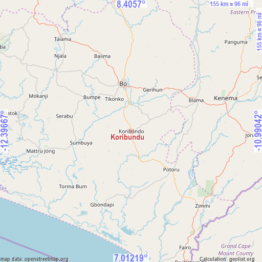
Koribundu GPS coordinates[2]
7° 42' 34.272" North, 11° 41' 36.744" West
| Map corner | latitude | longitude |
|---|---|---|
| Upper-left | 8.4057°, | -12.39667° |
| Center: | 7.70952°, | -11.69354° |
| Lower-right: | 7.01219°, | -10.99042° |
| Map W x H: | 154.9×154.9 km | = 96.3×96.3mi |
| max Lat: | 9.91376° ⇑85.5% North |
| Koribundu: | 7.70952° |
| min Lat: | ⇓14.5% South 7.24611° |
| min Long | Koribundu | max Long |
| -13.28972° | -11.69354° | -10.37135° |
| W 49.4%⇐ | ⇒50.6% E |
Elevation
Elevation of Koribundu is 79 m = 259 ft, and this is 78.2 m = 257 ft below average elevation for this country.
| Max E: |
564 m = 1850 ft | 61.4% |
| Avg. | 157.2 m = 516 ft | |
| Koribundu | 79 m = 259 ft | |
Min E: |
1 m = 3 ft | 38.6% |
See also: Sierra Leone elevation on elevation.city.
Geographical zone
Koribundu is located in North Torrid zone (between Equator and Tropic of Cancer). Distance of Equator is 857.2 km =532.6 mi to South.| Distance of | km | miles | from Koribundu |
|---|---|---|---|
| North Pole | 9149.8 | 5685.4 | to North |
| Arctic Circle | 6544 | 4066.3 | to North |
| Tropic Cancer | 1748.7 | 1086.6 | to North |
| Equator | 857.2 | 532.6 | to South |


Nearby cities:
15 places around Koribundu: (largest is in red/bold)
• Baiima
47.5 km =29.5 mi,  339°
339°
• Baoma
31.7 km =19.7 mi,  355°
355°
• Blama
42.5 km =26.4 mi,  64°
64°
• Bo
28.8 km =17.9 mi,  350°
350°
• Bumpe
30.9 km =19.2 mi,  311°
311°
• Foindu
37.3 km =23.2 mi,  153°
153°
• Gandorhun
17.2 km =10.7 mi,  179°
179°
• Gandorhun
28.3 km =17.6 mi,  212°
212°
• Gbewebu
20 km =12.4 mi, 151°
• Mamboma
42 km =26.1 mi,  0°
0°
• Potoru
32.7 km =20.3 mi,  133°
133°
• Pujehun
39.2 km =24.4 mi, 184°
• Serabu
40.7 km =25.3 mi,  283°
283°
• Sumbuya
30.2 km =18.8 mi,  256°
256°
• Tongole
36.7 km =22.8 mi,  218°
218°
Sources, notices
• [Note1] Compared only with cities in Sierra Leone existing in our database
• [Src1] Map data: © OpenStreetMap contributors (CC-BY-SA)
• [Src2] Other city data from geonames.org with taken over terms of usage.
• [Src3] Geographical zone / Annual Mean Temperature by Robert A. Rohde @ Wikipedia
