Foindu geodata
Foindu (Southern Province) is a populated place; located in Sierra Leone in Africa/Freetown (GMT+0) time zone. With population of 5,868 people, there are 36 cities with bigger population in this country. Compared to other cities in Sierra Leone, 96.4% of cities are located further ↑North; 56.6% of cities are located further ←West and 68.7% of cities have higher elevation than Foindu. Note1


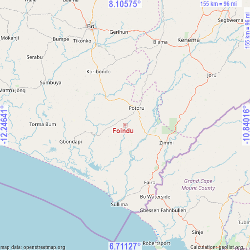
Foindu GPS coordinates[2]
7° 24' 32.616" North, 11° 32' 35.808" West
| Map corner | latitude | longitude |
|---|---|---|
| Upper-left | 8.10575°, | -12.24641° |
| Center: | 7.40906°, | -11.54328° |
| Lower-right: | 6.71127°, | -10.84016° |
| Map W x H: | 155.1×155.1 km | = 96.4×96.4mi |
| max Lat: | 9.91376° ⇑96.4% North |
| Foindu: | 7.40906° |
| min Lat: | ⇓3.6% South 7.24611° |
| min Long | Foindu | max Long |
| -13.28972° | -11.54328° | -10.37135° |
| W 56.6%⇐ | ⇒43.4% E |
Elevation
Elevation of Foindu is 58 m = 190 ft, and this is 99.2 m = 325 ft below average elevation for this country.
| Max E: |
564 m = 1850 ft | 68.7% |
| Avg. | 157.2 m = 516 ft | |
| Foindu | 58 m = 190 ft | |
Min E: |
1 m = 3 ft | 31.3% |
See also: Sierra Leone elevation on elevation.city.
Geographical zone
Foindu is located in North Torrid zone (between Equator and Tropic of Cancer). Distance of Equator is 823.8 km =511.9 mi to South.| Distance of | km | miles | from Foindu |
|---|---|---|---|
| North Pole | 9183.3 | 5706.2 | to North |
| Arctic Circle | 6577.4 | 4087 | to North |
| Tropic Cancer | 1782.1 | 1107.3 | to North |
| Equator | 823.8 | 511.9 | to South |


Nearby cities:
15 places around Foindu: (largest is in red/bold)
• Blama
56.2 km =34.9 mi,  22°
22°
• Bo
65.4 km =40.6 mi,  340°
340°
• Bomi
18.2 km =11.3 mi,  173°
173°
• Bumpe
66.9 km =41.6 mi,  323°
323°
• Gandorhun
23.1 km =14.4 mi,  314°
314°
• Gandorhun
33.1 km =20.6 mi,  286°
286°
• Gbewebu
17.3 km =10.7 mi, 335°
• Gorahun
34.1 km =21.2 mi,  79°
79°
• Kenema
65 km =40.4 mi,  36°
36°
• Koribundu
37.3 km =23.2 mi,  333°
333°
• Potoru
12.9 km =8 mi,  33°
33°
• Pujehun
20.4 km =12.7 mi,  253°
253°
• Sumbuya
53.1 km =33 mi,  299°
299°
• Tongole
39.7 km =24.7 mi,  276°
276°
• Zimmi
28 km =17.4 mi,  112°
112°
Sources, notices
• [Note1] Compared only with cities in Sierra Leone existing in our database
• [Src1] Map data: © OpenStreetMap contributors (CC-BY-SA)
• [Src2] Other city data from geonames.org with taken over terms of usage.
• [Src3] Geographical zone / Annual Mean Temperature by Robert A. Rohde @ Wikipedia
