Pujehun geodata
Pujehun (Southern Province) is a populated place; located in Sierra Leone in Africa/Freetown (GMT+0) time zone. With population of 7,926 people, there are 25 cities with bigger population in this country. Compared to other cities in Sierra Leone, 97.6% of cities are located further ↑North; 53% of cities are located further →East and 85.5% of cities have higher elevation than Pujehun. Note1


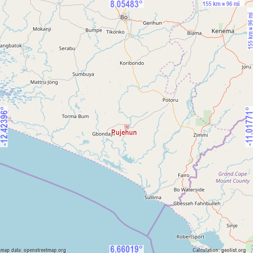
Pujehun GPS coordinates[2]
7° 21' 29.016" North, 11° 43' 14.988" West
| Map corner | latitude | longitude |
|---|---|---|
| Upper-left | 8.05483°, | -12.42396° |
| Center: | 7.35806°, | -11.72083° |
| Lower-right: | 6.66019°, | -11.01771° |
| Map W x H: | 155.1×155.1 km | = 96.4×96.4mi |
| max Lat: | 9.91376° ⇑97.6% North |
| Pujehun: | 7.35806° |
| min Lat: | ⇓2.4% South 7.24611° |
| min Long | Pujehun | max Long |
| -13.28972° | -11.72083° | -10.37135° |
| W 47%⇐ | ⇒53% E |
Elevation
Elevation of Pujehun is 26 m = 85 ft, and this is 131.2 m = 430 ft below average elevation for this country.
| Max E: |
564 m = 1850 ft | 85.5% |
| Avg. | 157.2 m = 516 ft | |
| Pujehun | 26 m = 85 ft | |
Min E: |
1 m = 3 ft | 14.5% |
See also: Sierra Leone elevation on elevation.city.
Geographical zone
Pujehun is located in North Torrid zone (between Equator and Tropic of Cancer). Distance of Equator is 818.1 km =508.3 mi to South.| Distance of | km | miles | from Pujehun |
|---|---|---|---|
| North Pole | 9188.9 | 5709.7 | to North |
| Arctic Circle | 6583 | 4090.5 | to North |
| Tropic Cancer | 1787.8 | 1110.9 | to North |
| Equator | 818.1 | 508.3 | to South |


Nearby cities:
15 places around Pujehun: (largest is in red/bold)
• Baoma
70.7 km =43.9 mi,  0°
0°
• Bo
67.5 km =41.9 mi,  358°
358°
• Bomi
24.8 km =15.4 mi,  120°
120°
• Bumpe
62.8 km =39 mi,  341°
341°
• Foindu
20.4 km =12.7 mi,  73°
73°
• Gandorhun
19.4 km =12.1 mi,  321°
321°
• Gandorhun
22.1 km =13.7 mi,  8°
8°
• Gbewebu
24.8 km =15.4 mi,  30°
30°
• Gorahun
54.4 km =33.8 mi,  77°
77°
• Koribundu
39.2 km =24.4 mi, 4°
• Potoru
31.3 km =19.4 mi,  58°
58°
• Serabu
60.7 km =37.7 mi, 322°
• Sumbuya
41.7 km =25.9 mi, 320°
• Tongole
22.4 km =13.9 mi,  297°
297°
• Zimmi
45.8 km =28.5 mi,  96°
96°
Sources, notices
• [Note1] Compared only with cities in Sierra Leone existing in our database
• [Src1] Map data: © OpenStreetMap contributors (CC-BY-SA)
• [Src2] Other city data from geonames.org with taken over terms of usage.
• [Src3] Geographical zone / Annual Mean Temperature by Robert A. Rohde @ Wikipedia
