Gandorhun geodata
Gandorhun (Southern Province) is a populated place; located in Sierra Leone in Africa/Freetown (GMT+0) time zone. With population of 12,288 people, there are 16 cities with bigger population in this country. Compared to other cities in Sierra Leone, 88% of cities are located further ↑North; 50.6% of cities are located further ←West and 68.7% of cities have higher elevation than Gandorhun. Note1


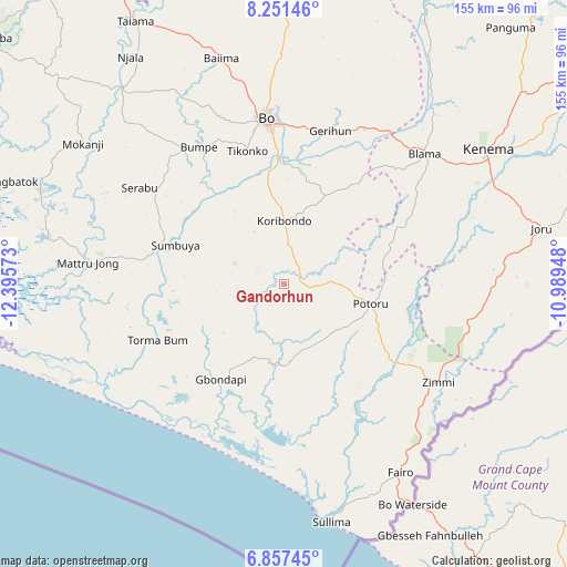
Gandorhun GPS coordinates[2]
7° 33' 18.072" North, 11° 41' 33.36" West
| Map corner | latitude | longitude |
|---|---|---|
| Upper-left | 8.25146°, | -12.39573° |
| Center: | 7.55502°, | -11.6926° |
| Lower-right: | 6.85745°, | -10.98948° |
| Map W x H: | 155×155 km | = 96.3×96.3mi |
| max Lat: | 9.91376° ⇑88% North |
| Gandorhun: | 7.55502° |
| min Lat: | ⇓12% South 7.24611° |
| min Long | Gandorhun | max Long |
| -13.28972° | -11.6926° | -10.37135° |
| W 50.6%⇐ | ⇒49.4% E |
Elevation
Elevation of Gandorhun is 58 m = 190 ft, and this is 99.2 m = 325 ft below average elevation for this country.
| Max E: |
564 m = 1850 ft | 68.7% |
| Avg. | 157.2 m = 516 ft | |
| Gandorhun | 58 m = 190 ft | |
Min E: |
1 m = 3 ft | 31.3% |
See also: Sierra Leone elevation on elevation.city.
Geographical zone
Gandorhun is located in North Torrid zone (between Equator and Tropic of Cancer). Distance of Equator is 840 km =522 mi to South.| Distance of | km | miles | from Gandorhun |
|---|---|---|---|
| North Pole | 9167 | 5696.1 | to North |
| Arctic Circle | 6561.1 | 4076.9 | to North |
| Tropic Cancer | 1765.9 | 1097.3 | to North |
| Equator | 840 | 522 | to South |


Nearby cities:
15 places around Gandorhun: (largest is in red/bold)
• Baoma
48.8 km =30.3 mi,  357°
357°
• Bo
45.8 km =28.5 mi,  353°
353°
• Bomi
39 km =24.2 mi,  151°
151°
• Bumpe
44.2 km =27.5 mi,  327°
327°
• Foindu
23.1 km =14.4 mi,  134°
134°
• Gandorhun
16.6 km =10.3 mi,  246°
246°
• Gbewebu
9.4 km =5.8 mi,  92°
92°
• Gorahun
51 km =31.7 mi,  101°
101°
• Koribundu
17.2 km =10.7 mi, 359°
• Potoru
24.2 km =15 mi, 103°
• Pujehun
22.1 km =13.7 mi,  188°
188°
• Serabu
47.7 km =29.6 mi,  303°
303°
• Sumbuya
31.3 km =19.4 mi,  289°
289°
• Tongole
25.7 km =16 mi,  243°
243°
• Zimmi
50.2 km =31.2 mi,  122°
122°
Sources, notices
• [Note1] Compared only with cities in Sierra Leone existing in our database
• [Src1] Map data: © OpenStreetMap contributors (CC-BY-SA)
• [Src2] Other city data from geonames.org with taken over terms of usage.
• [Src3] Geographical zone / Annual Mean Temperature by Robert A. Rohde @ Wikipedia
