Bomi geodata
Bomi (Southern Province) is a populated place; located in Sierra Leone in Africa/Freetown (GMT+0) time zone. With population of 5,463 people, there are 39 cities with bigger population in this country. Compared to other cities in Sierra Leone, 100% of cities are located further ↑North; 57.8% of cities are located further ←West and 74.7% of cities have higher elevation than Bomi. Note1


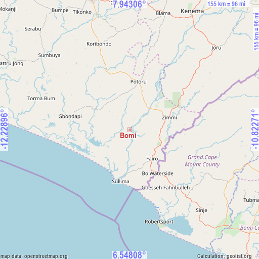
Bomi GPS coordinates[2]
7° 14' 45.996" North, 11° 31' 32.988" West
| Map corner | latitude | longitude |
|---|---|---|
| Upper-left | 7.94306°, | -12.22896° |
| Center: | 7.24611°, | -11.52583° |
| Lower-right: | 6.54808°, | -10.82271° |
| Map W x H: | 155.1×155.1 km | = 96.4×96.4mi |
| max Lat: | 9.91376° ⇑100% North |
| Bomi: | 7.24611° |
| min Lat: | ⇓0% South 7.24611° |
| min Long | Bomi | max Long |
| -13.28972° | -11.52583° | -10.37135° |
| W 57.8%⇐ | ⇒42.2% E |
Elevation
Elevation of Bomi is 45 m = 148 ft, and this is 112.2 m = 368 ft below average elevation for this country.
| Max E: |
564 m = 1850 ft | 74.7% |
| Avg. | 157.2 m = 516 ft | |
| Bomi | 45 m = 148 ft | |
Min E: |
1 m = 3 ft | 25.3% |
See also: Sierra Leone elevation on elevation.city.
Geographical zone
Bomi is located in North Torrid zone (between Equator and Tropic of Cancer). Distance of Equator is 805.7 km =500.6 mi to South.| Distance of | km | miles | from Bomi |
|---|---|---|---|
| North Pole | 9201.4 | 5717.5 | to North |
| Arctic Circle | 6595.5 | 4098.3 | to North |
| Tropic Cancer | 1800.2 | 1118.6 | to North |
| Equator | 805.7 | 500.6 | to South |


Nearby cities:
15 places around Bomi: (largest is in red/bold)
• Blama
72.7 km =45.2 mi,  15°
15°
• Bo
83.3 km =51.8 mi,  343°
343°
• Bumpe
83.1 km =51.6 mi,  329°
329°
• Foindu
18.2 km =11.3 mi,  353°
353°
• Gandorhun
39 km =24.2 mi, 331°
• Gandorhun
43.5 km =27 mi,  309°
309°
• Gbewebu
35.1 km =21.8 mi, 345°
• Gorahun
39.8 km =24.7 mi,  52°
52°
• Kenema
79.3 km =49.3 mi,  27°
27°
• Koribundu
54.7 km =34 mi, 340°
• Potoru
29.4 km =18.3 mi,  10°
10°
• Pujehun
24.8 km =15.4 mi,  300°
300°
• Sumbuya
65.5 km =40.7 mi, 312°
• Tongole
47.2 km =29.3 mi, 298°
• Zimmi
25.1 km =15.6 mi,  72°
72°
Sources, notices
• [Note1] Compared only with cities in Sierra Leone existing in our database
• [Src1] Map data: © OpenStreetMap contributors (CC-BY-SA)
• [Src2] Other city data from geonames.org with taken over terms of usage.
• [Src3] Geographical zone / Annual Mean Temperature by Robert A. Rohde @ Wikipedia
