Torit geodata
Torit (Imatong) is a seat of a first-order administrative division; located in South Sudan in Africa/Juba (GMT+2) time zone. With population of 20,048 people, there are 11 cities with bigger population in this country. Compared to other cities in South Sudan, 93.9% of cities are located further ↑North; 81.8% of cities are located further ←West and 81.8% of cities have lower elevation than Torit. Note1


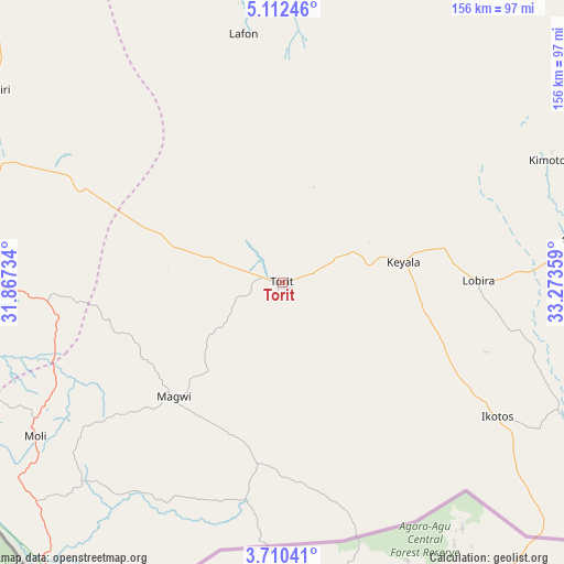
Torit GPS coordinates[2]
4° 24' 42.372" North, 32° 34' 13.656" East
| Map corner | latitude | longitude |
|---|---|---|
| Upper-left | 5.11246°, | 31.86734° |
| Center: | 4.41177°, | 32.57046° |
| Lower-right: | 3.71041°, | 33.27359° |
| Map W x H: | 155.9×155.9 km | = 96.9×96.9mi |
| max Lat: | 11.7431° ⇑93.9% North |
| Torit: | 4.41177° |
| min Lat: | ⇓6.1% South 3.86512° |
| min Long | Torit | max Long |
| 25.67833° | 32.57046° | 33.92621° |
| W 81.8%⇐ | ⇒18.2% E |
Elevation
Elevation of Torit is 617 m = 2024 ft, and this is 128.1 m = 420 ft above average elevation for this country.
| Max E: |
836 m = 2743 ft | 18.2% |
| Torit | 617 m 2024 ft | |
| Avg. | 488.9 m = 1604 ft | |
Min E: |
392 m = 1286 ft | 81.8% |
See also: South Sudan elevation on elevation.city.
Geographical zone
Torit is located in North Torrid zone (between Equator and Tropic of Cancer). Distance of Equator is 490.5 km =304.8 mi to South.| Distance of | km | miles | from Torit |
|---|---|---|---|
| North Pole | 9516.5 | 5913.3 | to North |
| Arctic Circle | 6910.6 | 4294 | to North |
| Tropic Cancer | 2115.4 | 1314.4 | to North |
| Equator | 490.5 | 304.8 | to South |


Nearby cities:
14 places around Torit: (largest is in red/bold)
• Akobo
378.8 km =235.4 mi,  7°
7°
• Ayod
432 km =268.4 mi,  342°
342°
• Bor
229.1 km =142.4 mi,  330°
330°
• Juba
119.9 km =74.5 mi,  294°
294°
• Kapoeta
120 km =74.6 mi,  70°
70°
• Maridi
348.2 km =216.4 mi,  279°
279°
• Mundri
269.7 km =167.6 mi, 292°
• Pajok
61.6 km =38.3 mi,  189°
189°
• Pibor
272.5 km =169.3 mi, 13°
• Rumbek
416.4 km =258.7 mi,  309°
309°
• Terekeka
146.3 km =90.9 mi,  321°
321°
• Waat
421.4 km =261.8 mi,  353°
353°
• Yei
213 km =132.4 mi,  260°
260°
• Yirol
330.6 km =205.4 mi, 316°
Sources, notices
• [Note1] Compared only with cities in South Sudan existing in our database
• [Src1] Map data: © OpenStreetMap contributors (CC-BY-SA)
• [Src2] Other city data from geonames.org with taken over terms of usage.
• [Src3] Geographical zone / Annual Mean Temperature by Robert A. Rohde @ Wikipedia
