Mundri geodata
Mundri (Amadi State) is a seat of a first-order administrative division; located in South Sudan in Africa/Juba (GMT+2) time zone. In our database, there are 19 cities with bigger population. Compared to other cities in South Sudan, 78.8% of cities are located further ↑North; 51.5% of cities are located further →East and 78.8% of cities have lower elevation than Mundri. Note1


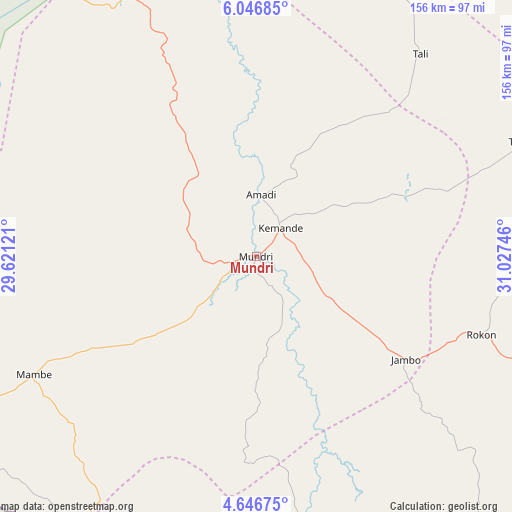
Mundri GPS coordinates[2]
5° 20' 49.92" North, 30° 19' 27.588" East
| Map corner | latitude | longitude |
|---|---|---|
| Upper-left | 6.04685°, | 29.62121° |
| Center: | 5.3472°, | 30.32433° |
| Lower-right: | 4.64675°, | 31.02746° |
| Map W x H: | 155.7×155.7 km | = 96.7×96.7mi |
| max Lat: | 11.7431° ⇑78.8% North |
| Mundri: | 5.3472° |
| min Lat: | ⇓21.2% South 3.86512° |
| min Long | Mundri | max Long |
| 25.67833° | 30.32433° | 33.92621° |
| W 48.5%⇐ | ⇒51.5% E |
Elevation
Elevation of Mundri is 560 m = 1837 ft, and this is 71.1 m = 233 ft above average elevation for this country.
| Max E: |
836 m = 2743 ft | 21.2% |
| Mundri | 560 m 1837 ft | |
| Avg. | 488.9 m = 1604 ft | |
Min E: |
392 m = 1286 ft | 78.8% |
See also: South Sudan elevation on elevation.city.
Geographical zone
Mundri is located in North Torrid zone (between Equator and Tropic of Cancer). Distance of Equator is 594.6 km =369.5 mi to South.| Distance of | km | miles | from Mundri |
|---|---|---|---|
| North Pole | 9412.5 | 5848.7 | to North |
| Arctic Circle | 6806.6 | 4229.4 | to North |
| Tropic Cancer | 2011.4 | 1249.8 | to North |
| Equator | 594.6 | 369.5 | to South |


Nearby cities:
15 places around Mundri: (largest is in red/bold)
• Ayod
331 km =205.7 mi,  21°
21°
• Bor
166.8 km =103.6 mi,  54°
54°
• Cueibet
221.5 km =137.6 mi,  327°
327°
• Juba
149.8 km =93.1 mi,  111°
111°
• Leer
329.3 km =204.6 mi,  356°
356°
• Maridi
106.1 km =65.9 mi,  243°
243°
• Pajok
290.4 km =180.4 mi,  124°
124°
• Rumbek
177.3 km =110.2 mi,  336°
336°
• Tambura
317.5 km =197.3 mi,  275°
275°
• Terekeka
158.3 km =98.4 mi,  86°
86°
• Tonj
281.1 km =174.7 mi,  319°
319°
• Torit
269.7 km =167.6 mi, 112°
• Yambio
230.6 km =143.3 mi,  248°
248°
• Yei
144.7 km =89.9 mi,  164°
164°
• Yirol
135.4 km =84.1 mi,  8°
8°
Sources, notices
• [Note1] Compared only with cities in South Sudan existing in our database
• [Src1] Map data: © OpenStreetMap contributors (CC-BY-SA)
• [Src2] Other city data from geonames.org with taken over terms of usage.
• [Src3] Geographical zone / Annual Mean Temperature by Robert A. Rohde @ Wikipedia
