Juba geodata
Juba is a capital of a political entity; located in South Sudan in Africa/Juba (GMT+2) time zone. With population of 450,000 people, there are 0 cities with bigger population in this country. Compared to other cities in South Sudan, 84.8% of cities are located further ↑North; 63.6% of cities are located further ←West and 72.7% of cities have lower elevation than Juba. Note1


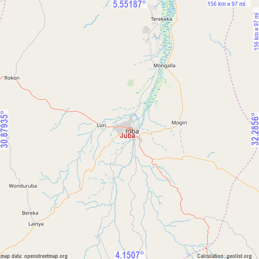
Juba GPS coordinates[2]
4° 51' 5.94" North, 31° 34' 56.892" East
| Map corner | latitude | longitude |
|---|---|---|
| Upper-left | 5.55187°, | 30.87935° |
| Center: | 4.85165°, | 31.58247° |
| Lower-right: | 4.1507°, | 32.2856° |
| Map W x H: | 155.8×155.8 km | = 96.8×96.8mi |
| max Lat: | 11.7431° ⇑84.8% North |
| Juba: | 4.85165° |
| min Lat: | ⇓15.2% South 3.86512° |
| min Long | Juba | max Long |
| 25.67833° | 31.58247° | 33.92621° |
| W 63.6%⇐ | ⇒36.4% E |
Elevation
Elevation of Juba is 518 m = 1699 ft, and this is 29.1 m = 95 ft above average elevation for this country.
| Max E: |
836 m = 2743 ft | 27.3% |
| Juba | 518 m 1699 ft | |
| Avg. | 488.9 m = 1604 ft | |
Min E: |
392 m = 1286 ft | 72.7% |
See also: Juba elevation on elevation.city.
Geographical zone
Juba is located in North Torrid zone (between Equator and Tropic of Cancer). Distance of Equator is 539.5 km =335.2 mi to South.| Distance of | km | miles | from Juba |
|---|---|---|---|
| North Pole | 9467.6 | 5882.9 | to North |
| Arctic Circle | 6861.7 | 4263.7 | to North |
| Tropic Cancer | 2066.5 | 1284.1 | to North |
| Equator | 539.5 | 335.2 | to South |


Nearby cities:
15 places around Juba: (largest is in red/bold)
• Akobo
362.6 km =225.3 mi,  25°
25°
• Ayod
364.1 km =226.2 mi,  356°
356°
• Bor
150.9 km =93.8 mi, 358°
• Cueibet
353.9 km =219.9 mi,  313°
313°
• Kapoeta
222.8 km =138.4 mi,  92°
92°
• Maridi
234.2 km =145.5 mi,  271°
271°
• Mundri
149.8 km =93.1 mi,  291°
291°
• Pajok
148.3 km =92.1 mi,  137°
137°
• Pibor
276 km =171.5 mi,  38°
38°
• Rumbek
302.7 km =188.1 mi,  315°
315°
• Terekeka
68.4 km =42.5 mi,  15°
15°
• Torit
119.9 km =74.5 mi,  114°
114°
• Yambio
354.7 km =220.4 mi,  264°
264°
• Yei
131.1 km =81.5 mi,  230°
230°
• Yirol
224 km =139.2 mi,  327°
327°
Sources, notices
• [Note1] Compared only with cities in South Sudan existing in our database
• [Src1] Map data: © OpenStreetMap contributors (CC-BY-SA)
• [Src2] Other city data from geonames.org with taken over terms of usage.
• [Src3] Geographical zone / Annual Mean Temperature by Robert A. Rohde @ Wikipedia
