Yirol geodata
Yirol (Eastern Lakes) is a seat of a first-order administrative division; located in South Sudan in Africa/Juba (GMT+2) time zone. In our database, there are 19 cities with bigger population. Compared to other cities in South Sudan, 66.7% of cities are located further ↑North; 51.5% of cities are located further ←West and 63.6% of cities have lower elevation than Yirol. Note1


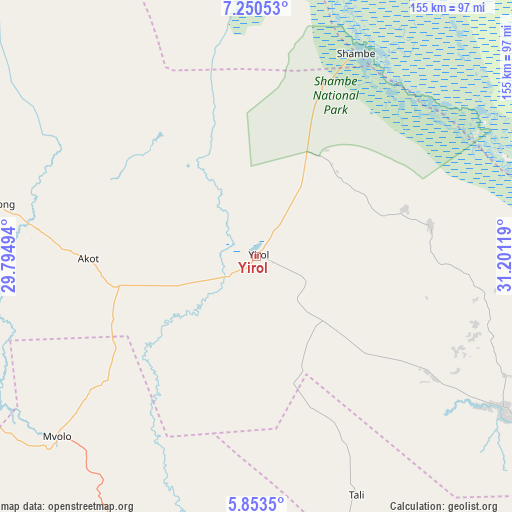
Yirol GPS coordinates[2]
6° 33' 9" North, 30° 29' 53.016" East
| Map corner | latitude | longitude |
|---|---|---|
| Upper-left | 7.25053°, | 29.79494° |
| Center: | 6.5525°, | 30.49806° |
| Lower-right: | 5.8535°, | 31.20119° |
| Map W x H: | 155.3×155.3 km | = 96.5×96.5mi |
| max Lat: | 11.7431° ⇑66.7% North |
| Yirol: | 6.5525° |
| min Lat: | ⇓33.3% South 3.86512° |
| min Long | Yirol | max Long |
| 25.67833° | 30.49806° | 33.92621° |
| W 51.5%⇐ | ⇒48.5% E |
Elevation
Elevation of Yirol is 444 m = 1457 ft, and this is 44.9 m = 147 ft below average elevation for this country.
| Max E: |
836 m = 2743 ft | 36.4% |
| Avg. | 488.9 m = 1604 ft | |
| Yirol | 444 m = 1457 ft | |
Min E: |
392 m = 1286 ft | 63.6% |
See also: South Sudan elevation on elevation.city.
Geographical zone
Yirol is located in North Torrid zone (between Equator and Tropic of Cancer). Distance of Equator is 728.6 km =452.7 mi to South.| Distance of | km | miles | from Yirol |
|---|---|---|---|
| North Pole | 9278.5 | 5765.4 | to North |
| Arctic Circle | 6672.6 | 4146.2 | to North |
| Tropic Cancer | 1877.3 | 1166.5 | to North |
| Equator | 728.6 | 452.7 | to South |


Nearby cities:
15 places around Yirol: (largest is in red/bold)
• Akobo
308.9 km =191.9 mi,  63°
63°
• Ayod
201.4 km =125.1 mi,  29°
29°
• Bor
123.3 km =76.6 mi,  108°
108°
• Cueibet
147.9 km =91.9 mi,  290°
290°
• Juba
224 km =139.2 mi,  147°
147°
• Leer
198.6 km =123.4 mi,  348°
348°
• Maridi
214.6 km =133.3 mi,  212°
212°
• Mundri
135.4 km =84.1 mi,  188°
188°
• Pibor
292 km =181.4 mi,  84°
84°
• Rumbek
94.9 km =59 mi, 287°
• Terekeka
185.4 km =115.2 mi,  131°
131°
• Tonj
216.4 km =134.5 mi, 291°
• Waat
256.9 km =159.6 mi,  45°
45°
• Wau
304.8 km =189.4 mi, 294°
• Yei
274 km =170.3 mi,  175°
175°
Sources, notices
• [Note1] Compared only with cities in South Sudan existing in our database
• [Src1] Map data: © OpenStreetMap contributors (CC-BY-SA)
• [Src2] Other city data from geonames.org with taken over terms of usage.
• [Src3] Geographical zone / Annual Mean Temperature by Robert A. Rohde @ Wikipedia
