Leer geodata
Leer (Southern Liech) is a seat of a first-order administrative division; located in South Sudan in Africa/Juba (GMT+2) time zone. With population of 10,486 people, there are 14 cities with bigger population in this country. Compared to other cities in South Sudan, 63.6% of cities are located further ↓South; 54.5% of cities are located further →East and 90.9% of cities have higher elevation than Leer. Note1


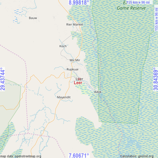
Leer GPS coordinates[2]
8° 18' 11.016" North, 30° 8' 26.016" East
| Map corner | latitude | longitude |
|---|---|---|
| Upper-left | 8.99818°, | 29.43744° |
| Center: | 8.30306°, | 30.14056° |
| Lower-right: | 7.60671°, | 30.84369° |
| Map W x H: | 154.7×154.7 km | = 96.1×96.1mi |
| max Lat: | 11.7431° ⇑36.4% North |
| Leer: | 8.30306° |
| min Lat: | ⇓63.6% South 3.86512° |
| min Long | Leer | max Long |
| 25.67833° | 30.14056° | 33.92621° |
| W 45.5%⇐ | ⇒54.5% E |
Elevation
Elevation of Leer is 397 m = 1302 ft, and this is 91.9 m = 302 ft below average elevation for this country.
| Max E: |
836 m = 2743 ft | 90.9% |
| Avg. | 488.9 m = 1604 ft | |
| Leer | 397 m = 1302 ft | |
Min E: |
392 m = 1286 ft | 9.1% |
See also: South Sudan elevation on elevation.city.
Geographical zone
Leer is located in North Torrid zone (between Equator and Tropic of Cancer). Distance of Equator is 923.2 km =573.6 mi to South.| Distance of | km | miles | from Leer |
|---|---|---|---|
| North Pole | 9083.8 | 5644.4 | to North |
| Arctic Circle | 6478 | 4025.2 | to North |
| Tropic Cancer | 1682.7 | 1045.6 | to North |
| Equator | 923.2 | 573.6 | to South |


Nearby cities:
15 places around Leer: (largest is in red/bold)
• Ayod
141 km =87.6 mi,  98°
98°
• Bentiu
112.6 km =70 mi,  340°
340°
• Bor
280.5 km =174.3 mi,  146°
146°
• Cueibet
172.8 km =107.4 mi,  214°
214°
• Gogrial
225.9 km =140.4 mi,  276°
276°
• Kodok
279 km =173.4 mi,  50°
50°
• Kuacjok
237.7 km =147.7 mi,  269°
269°
• Malakal
215.8 km =134.1 mi, 50°
• Mayen Abun
217.9 km =135.4 mi,  295°
295°
• Pariang
180.1 km =111.9 mi,  354°
354°
• Rumbek
174.1 km =108.2 mi,  197°
197°
• Tonj
197.7 km =122.8 mi,  234°
234°
• Waat
221.8 km =137.8 mi,  93°
93°
• Wau
246.1 km =152.9 mi,  254°
254°
• Yirol
198.6 km =123.4 mi,  168°
168°
Sources, notices
• [Note1] Compared only with cities in South Sudan existing in our database
• [Src1] Map data: © OpenStreetMap contributors (CC-BY-SA)
• [Src2] Other city data from geonames.org with taken over terms of usage.
• [Src3] Geographical zone / Annual Mean Temperature by Robert A. Rohde @ Wikipedia
