Sidvokodvo geodata
Sidvokodvo (Manzini) is a populated place; located in Eswatini in Africa/Mbabane (GMT+2) time zone. With population of 1,746 people, there are 19 cities with bigger population in this country. Compared to other cities in Eswatini, 68.2% of cities are located further ↑North; 59.1% of cities are located further ←West and 72.7% of cities have higher elevation than Sidvokodvo. Note1


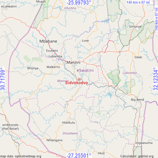
Sidvokodvo GPS coordinates[2]
26° 37' 41.52" South, 31° 25' 12.756" East
| Map corner | latitude | longitude |
|---|---|---|
| Upper-left | -25.99793°, | 30.71709° |
| Center: | -26.6282°, | 31.42021° |
| Lower-right: | -27.25501°, | 32.12334° |
| Map W x H: | 139.8×139.8 km | = 86.9×86.9mi |
| max Lat: | -25.82659° ⇑68.2% North |
| Sidvokodvo: | -26.6282° |
| min Lat: | ⇓31.8% South -27.31005° |
| min Long | Sidvokodvo | max Long |
| 31.01667° | 31.42021° | 31.95° |
| W 59.1%⇐ | ⇒40.9% E |
Elevation
Elevation of Sidvokodvo is 375 m = 1230 ft, and this is 303.5 m = 996 ft below average elevation for this country.
| Max E: |
1317 m = 4321 ft | 72.7% |
| Avg. | 678.5 m = 2226 ft | |
| Sidvokodvo | 375 m = 1230 ft | |
Min E: |
109 m = 358 ft | 27.3% |
See also: Eswatini elevation on elevation.city.
Geographical zone
Sidvokodvo is located in South temperate zone (between Tropic of Capricorn and the Antarctic Circle). Distance of this Southern Tropic circle is 354.9 km =220.5 mi to North.| Distance of | km | miles | from Sidvokodvo |
|---|---|---|---|
| Equator | 2960.8 | 1839.8 | to North |
| Tropic Capricorn | 354.9 | 220.5 | to North |
| Antarctic Circle | 4440.4 | 2759.1 | to South |
| South Pole | 7046.3 | 4378.4 | to South |


Nearby cities:
15 places around Sidvokodvo: (largest is in red/bold)
• Bhunya
41.1 km =25.5 mi,  282°
282°
• Big Bend
55.1 km =34.2 mi,  112°
112°
• Darkton
58.4 km =36.3 mi,  318°
318°
• Hlatikulu
40.2 km =25 mi,  193°
193°
• Hluti
68.3 km =42.4 mi,  163°
163°
• Kubuta
29.1 km =18.1 mi,  167°
167°
• Kwaluseni
18.3 km =11.4 mi,  331°
331°
• Lobamba
28.3 km =17.6 mi,  309°
309°
• Malkerns
24.5 km =15.2 mi,  286°
286°
• Manzini
14.9 km =9.3 mi,  344°
344°
• Mbabane
44.9 km =27.9 mi, 320°
• Mhlambanyatsi
44.8 km =27.8 mi,  296°
296°
• Nhlangano
58.1 km =36.1 mi,  202°
202°
• Nsoko
69.2 km =43 mi,  130°
130°
• Siteki
55.9 km =34.7 mi,  69°
69°
Sources, notices
• [Note1] Compared only with cities in Eswatini existing in our database
• [Src1] Map data: © OpenStreetMap contributors (CC-BY-SA)
• [Src2] Other city data from geonames.org with taken over terms of usage.
• [Src3] Geographical zone / Annual Mean Temperature by Robert A. Rohde @ Wikipedia
