Bhunya geodata
Bhunya (Manzini) is a populated place; located in Eswatini in Africa/Mbabane (GMT+2) time zone. With population of 3,046 people, there are 12 cities with bigger population in this country. Compared to other cities in Eswatini, 59.1% of cities are located further ↑North; 100% of cities are located further →East and 68.2% of cities have lower elevation than Bhunya. Note1


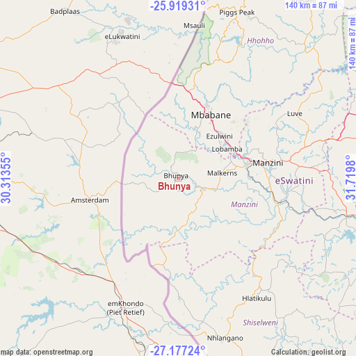
Bhunya GPS coordinates[2]
26° 33' 0" South, 31° 1' 0.012" East
| Map corner | latitude | longitude |
|---|---|---|
| Upper-left | -25.91931°, | 30.31355° |
| Center: | -26.55°, | 31.01667° |
| Lower-right: | -27.17724°, | 31.7198° |
| Map W x H: | 139.9×139.9 km | = 86.9×86.9mi |
| max Lat: | -25.82659° ⇑59.1% North |
| Bhunya: | -26.55° |
| min Lat: | ⇓40.9% South -27.31005° |
| min Long | Bhunya | max Long |
| 31.01667° | 31.01667° | 31.95° |
| W 0%⇐ | ⇒100% E |
Elevation
Elevation of Bhunya is 956 m = 3136 ft, and this is 277.5 m = 910 ft above average elevation for this country.
| Max E: |
1317 m = 4321 ft | 31.8% |
| Bhunya | 956 m 3136 ft | |
| Avg. | 678.5 m = 2226 ft | |
Min E: |
109 m = 358 ft | 68.2% |
See also: Eswatini elevation on elevation.city.
Geographical zone
Bhunya is located in South temperate zone (between Tropic of Capricorn and the Antarctic Circle). Distance of this Southern Tropic circle is 346.2 km =215.1 mi to North.| Distance of | km | miles | from Bhunya |
|---|---|---|---|
| Equator | 2952.1 | 1834.3 | to North |
| Tropic Capricorn | 346.2 | 215.1 | to North |
| Antarctic Circle | 4449.1 | 2764.5 | to South |
| South Pole | 7055 | 4383.8 | to South |


Nearby cities:
15 places around Bhunya: (largest is in red/bold)
• Bulembu
65.9 km =40.9 mi,  10°
10°
• Darkton
35.2 km =21.9 mi,  2°
2°
• Hlatikulu
56.7 km =35.2 mi,  147°
147°
• Kubuta
59.3 km =36.8 mi,  128°
128°
• Kwaluseni
32.4 km =20.1 mi,  76°
76°
• Lobamba
20.5 km =12.7 mi,  63°
63°
• Malkerns
16.7 km =10.4 mi,  96°
96°
• Manzini
36.6 km =22.7 mi, 81°
• Mbabane
28.4 km =17.6 mi,  24°
24°
• Mhlambanyatsi
11.1 km =6.9 mi, 0°
• Nhlangano
65.1 km =40.5 mi,  163°
163°
• Ntfonjeni
86.2 km =53.6 mi, 21°
• Piggs Peak
69.4 km =43.1 mi, 19°
• Sidvokodvo
41.1 km =25.5 mi, 102°
• Siteki
93.2 km =57.9 mi, 83°
Sources, notices
• [Note1] Compared only with cities in Eswatini existing in our database
• [Src1] Map data: © OpenStreetMap contributors (CC-BY-SA)
• [Src2] Other city data from geonames.org with taken over terms of usage.
• [Src3] Geographical zone / Annual Mean Temperature by Robert A. Rohde @ Wikipedia
