Big Bend geodata
Big Bend (Lubombo) is a populated place; located in Eswatini in Africa/Mbabane (GMT+2) time zone. With population of 10,342 people, there are 2 cities with bigger population in this country. Compared to other cities in Eswatini, 72.7% of cities are located further ↑North; 90.9% of cities are located further ←West and 100% of cities have higher elevation than Big Bend. Note1


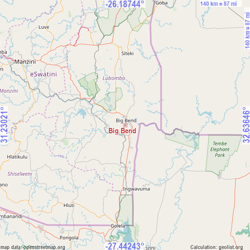
Big Bend GPS coordinates[2]
26° 49' 0.012" South, 31° 55' 59.988" East
| Map corner | latitude | longitude |
|---|---|---|
| Upper-left | -26.18744°, | 31.23021° |
| Center: | -26.81667°, | 31.93333° |
| Lower-right: | -27.44243°, | 32.63646° |
| Map W x H: | 139.5×139.5 km | = 86.7×86.7mi |
| max Lat: | -25.82659° ⇑72.7% North |
| Big Bend: | -26.81667° |
| min Lat: | ⇓27.3% South -27.31005° |
| min Long | Big Bend | max Long |
| 31.01667° | 31.93333° | 31.95° |
| W 90.9%⇐ | ⇒9.1% E |
Elevation
Elevation of Big Bend is 109 m = 358 ft, and this is 569.5 m = 1868 ft below average elevation for this country.
| Max E: |
1317 m = 4321 ft | 100% |
| Avg. | 678.5 m = 2226 ft | |
| Big Bend | 109 m = 358 ft | |
Min E: |
109 m = 358 ft | 0% |
See also: Eswatini elevation on elevation.city.
Geographical zone
Big Bend is located in South temperate zone (between Tropic of Capricorn and the Antarctic Circle). Distance of this Southern Tropic circle is 375.8 km =233.5 mi to North.| Distance of | km | miles | from Big Bend |
|---|---|---|---|
| Equator | 2981.7 | 1852.7 | to North |
| Tropic Capricorn | 375.8 | 233.5 | to North |
| Antarctic Circle | 4419.4 | 2746.1 | to South |
| South Pole | 7025.3 | 4365.3 | to South |


Nearby cities:
15 places around Big Bend: (largest is in red/bold)
• Hlatikulu
63 km =39.1 mi,  253°
253°
• Hluti
54.4 km =33.8 mi,  215°
215°
• Kubuta
45.3 km =28.1 mi,  260°
260°
• Kwaluseni
70.2 km =43.6 mi,  301°
301°
• Lavumisa
55 km =34.2 mi,  184°
184°
• Lobamba
82.6 km =51.3 mi, 298°
• Malkerns
79.5 km =49.4 mi,  290°
290°
• Manzini
65.4 km =40.6 mi, 302°
• Mhlume
87.5 km =54.4 mi,  354°
354°
• Nhlangano
79.9 km =49.6 mi, 245°
• Nsoko
24.1 km =15 mi, 176°
• Sidvokodvo
55.1 km =34.2 mi, 292°
• Siteki
40.5 km =25.2 mi,  1°
1°
• Tshaneni
95.1 km =59.1 mi, 346°
• Vuvulane
82.7 km =51.4 mi,  356°
356°
Sources, notices
• [Note1] Compared only with cities in Eswatini existing in our database
• [Src1] Map data: © OpenStreetMap contributors (CC-BY-SA)
• [Src2] Other city data from geonames.org with taken over terms of usage.
• [Src3] Geographical zone / Annual Mean Temperature by Robert A. Rohde @ Wikipedia
