Kwaluseni geodata
Kwaluseni (Manzini) is a populated place; located in Eswatini in Africa/Mbabane (GMT+2) time zone. With population of 3,395 people, there are 11 cities with bigger population in this country. Compared to other cities in Eswatini, 50% of cities are located further ↓South; 50% of cities are located further ←West and 54.5% of cities have lower elevation than Kwaluseni. Note1


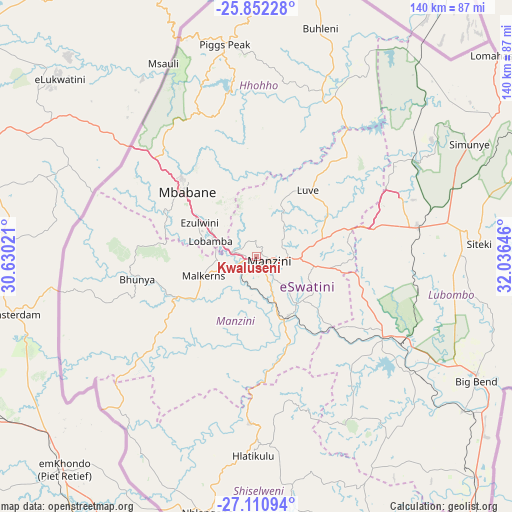
Kwaluseni GPS coordinates[2]
26° 28' 59.988" South, 31° 19' 59.988" East
| Map corner | latitude | longitude |
|---|---|---|
| Upper-left | -25.85228°, | 30.63021° |
| Center: | -26.48333°, | 31.33333° |
| Lower-right: | -27.11094°, | 32.03646° |
| Map W x H: | 139.9×140 km | = 86.9×87mi |
| max Lat: | -25.82659° ⇑50% North |
| Kwaluseni: | -26.48333° |
| min Lat: | ⇓50% South -27.31005° |
| min Long | Kwaluseni | max Long |
| 31.01667° | 31.33333° | 31.95° |
| W 50%⇐ | ⇒50% E |
Elevation
Elevation of Kwaluseni is 677 m = 2221 ft, and this is 1.5 m = 5 ft below average elevation for this country.
| Max E: |
1317 m = 4321 ft | 45.5% |
| Avg. | 678.5 m = 2226 ft | |
| Kwaluseni | 677 m = 2221 ft | |
Min E: |
109 m = 358 ft | 54.5% |
See also: Eswatini elevation on elevation.city.
Geographical zone
Kwaluseni is located in South temperate zone (between Tropic of Capricorn and the Antarctic Circle). Distance of this Southern Tropic circle is 338.8 km =210.5 mi to North.| Distance of | km | miles | from Kwaluseni |
|---|---|---|---|
| Equator | 2944.7 | 1829.8 | to North |
| Tropic Capricorn | 338.8 | 210.5 | to North |
| Antarctic Circle | 4456.5 | 2769.1 | to South |
| South Pole | 7062.4 | 4388.4 | to South |


Nearby cities:
15 places around Kwaluseni: (largest is in red/bold)
• Bhunya
32.4 km =20.1 mi,  256°
256°
• Big Bend
70.2 km =43.6 mi,  121°
121°
• Bulembu
60.8 km =37.8 mi,  340°
340°
• Darkton
40.8 km =25.4 mi,  312°
312°
• Hlatikulu
55.1 km =34.2 mi,  180°
180°
• Kubuta
46.9 km =29.1 mi,  161°
161°
• Lobamba
13.4 km =8.3 mi,  277°
277°
• Malkerns
17.6 km =10.9 mi,  238°
238°
• Manzini
5 km =3.1 mi,  110°
110°
• Mbabane
27.2 km =16.9 mi, 312°
• Mhlambanyatsi
31.7 km =19.7 mi, 276°
• Piggs Peak
58.7 km =36.5 mi,  351°
351°
• Sidvokodvo
18.3 km =11.4 mi,  151°
151°
• Siteki
61.2 km =38 mi,  86°
86°
• Tshaneni
67.5 km =41.9 mi,  34°
34°
Sources, notices
• [Note1] Compared only with cities in Eswatini existing in our database
• [Src1] Map data: © OpenStreetMap contributors (CC-BY-SA)
• [Src2] Other city data from geonames.org with taken over terms of usage.
• [Src3] Geographical zone / Annual Mean Temperature by Robert A. Rohde @ Wikipedia
