Siteki geodata
Siteki (Lubombo) is a seat of a first-order administrative division; located in Eswatini in Africa/Mbabane (GMT+2) time zone. With population of 6,152 people, there are 7 cities with bigger population in this country. Compared to other cities in Eswatini, 59.1% of cities are located further ↓South; 95.5% of cities are located further ←West and 50% of cities have lower elevation than Siteki. Note1


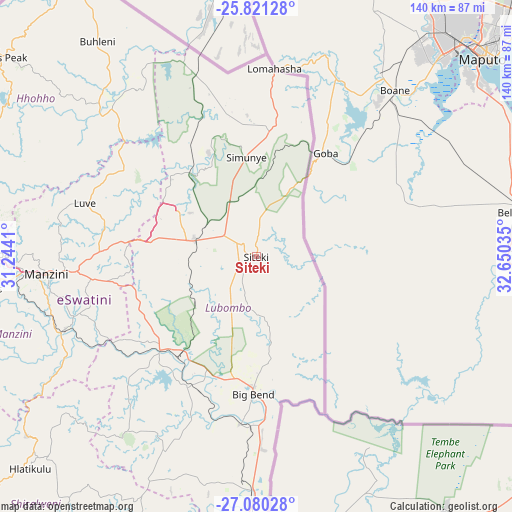
Siteki GPS coordinates[2]
26° 27' 9" South, 31° 56' 49.992" East
| Map corner | latitude | longitude |
|---|---|---|
| Upper-left | -25.82128°, | 31.2441° |
| Center: | -26.4525°, | 31.94722° |
| Lower-right: | -27.08028°, | 32.65035° |
| Map W x H: | 140×140 km | = 87×87mi |
| max Lat: | -25.82659° ⇑40.9% North |
| Siteki: | -26.4525° |
| min Lat: | ⇓59.1% South -27.31005° |
| min Long | Siteki | max Long |
| 31.01667° | 31.94722° | 31.95° |
| W 95.5%⇐ | ⇒4.5% E |
Elevation
Elevation of Siteki is 605 m = 1985 ft, and this is 73.5 m = 241 ft below average elevation for this country.
| Max E: |
1317 m = 4321 ft | 50% |
| Avg. | 678.5 m = 2226 ft | |
| Siteki | 605 m = 1985 ft | |
Min E: |
109 m = 358 ft | 50% |
See also: Eswatini elevation on elevation.city.
Geographical zone
Siteki is located in South temperate zone (between Tropic of Capricorn and the Antarctic Circle). Distance of this Southern Tropic circle is 335.3 km =208.3 mi to North.| Distance of | km | miles | from Siteki |
|---|---|---|---|
| Equator | 2941.2 | 1827.6 | to North |
| Tropic Capricorn | 335.3 | 208.3 | to North |
| Antarctic Circle | 4459.9 | 2771.3 | to South |
| South Pole | 7065.8 | 4390.5 | to South |


Nearby cities:
15 places around Siteki: (largest is in red/bold)
• Big Bend
40.5 km =25.2 mi,  181°
181°
• Hlatikulu
85.2 km =52.9 mi,  226°
226°
• Hluti
91.1 km =56.6 mi,  201°
201°
• Kubuta
66.5 km =41.3 mi,  223°
223°
• Kwaluseni
61.2 km =38 mi,  266°
266°
• Lobamba
74.4 km =46.2 mi, 268°
• Malkerns
77.1 km =47.9 mi,  260°
260°
• Manzini
56.7 km =35.2 mi, 264°
• Mbabane
82.5 km =51.3 mi,  280°
280°
• Mhlume
47.6 km =29.6 mi,  348°
348°
• Nsoko
64.6 km =40.1 mi, 179°
• Piggs Peak
88.7 km =55.1 mi,  308°
308°
• Sidvokodvo
55.9 km =34.7 mi,  249°
249°
• Tshaneni
57 km =35.4 mi,  336°
336°
• Vuvulane
42.6 km =26.5 mi, 350°
Sources, notices
• [Note1] Compared only with cities in Eswatini existing in our database
• [Src1] Map data: © OpenStreetMap contributors (CC-BY-SA)
• [Src2] Other city data from geonames.org with taken over terms of usage.
• [Src3] Geographical zone / Annual Mean Temperature by Robert A. Rohde @ Wikipedia
